Zone Look-up Map
Look up your zone on the IDO Zone Look-up Map.
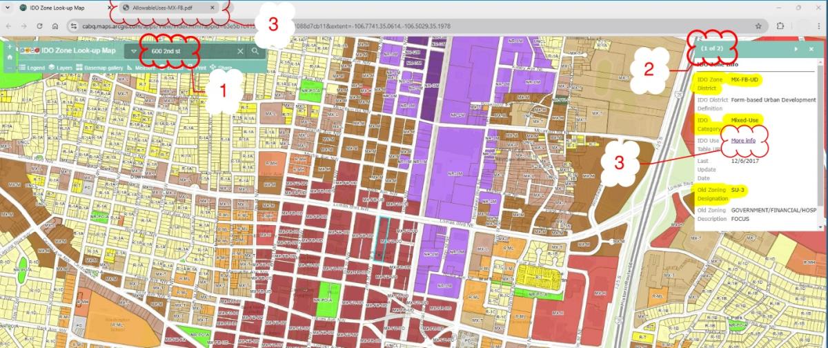
- Put your address in the search bar at the top of the map.
- Click on your property for more information, including a link to a summary of the uses allowed in your zone.
Step-by-Step Instructions
There are many ways to look up your zoning. The easiest method is to use the IDO Zone Look-up Map.
- Enter your address in the search bar and click on your property to see a pop-up window.
- The pop-up window displays your IDO zone district, zone category, old zoning designation, and a link for the Use Table that shows allowable uses in your zone.
- Click on "More Info" next to “IDO Use Table” to open a new tab with general information on your zone district and the allowable uses in your zone.
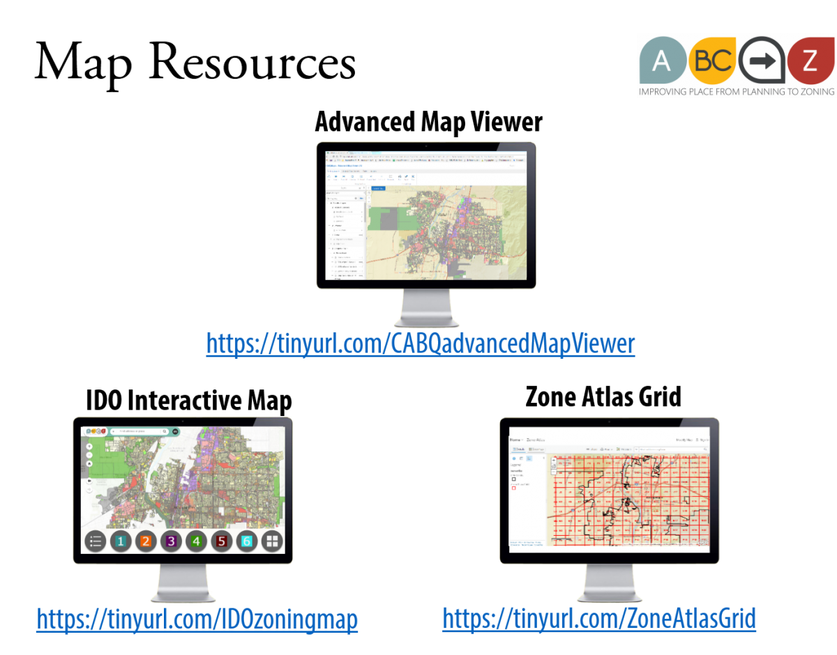
For information beyond zoning, there are 3 online maps that can help you find whether you are in an Overlay zone, identify which Development Area you are in (such as Area of Change or Area of Consistency), and identify important information such as geographic factors that may impact the uses allowed on your property, development standards that will apply to a project, and the process that you will need to go through to get a development project approved.
- Advanced Map Viewer: This comprehensive interactive map provides the most layers of information, but may be overwhelming if you only have a simple question. Some of the layers of information in this map include property ownership, IDO information, community facilities, political districts, environmental constraints, policy planning areas, and designated areas such as public improvement districts, city landmarks, and registered historic places.
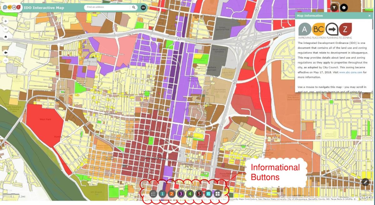
- IDO Interactive Map: This interactive map provides layers of information specific to the IDO but does not have the full extent of information from the Advanced Map Viewer that may be helpful.
- Button 1 = Basic layers of information
- Button 2 = Mapping designations established by the ABC Comprehensive Plan that affect IDO standards
- Button 3 = Overlay zones which change development standards for properties within their boundaries (i.e. Section 3 of the IDO)
- Button 4 = Use-specific standards tailored for small areas (i.e. Subsection 4-3 of the IDO)
- Button 5 = Development standards tailored to protect small areas, residential neighborhoods, Major Public Open Space, or Sensitive Lands (as regulated by Section 5 of the IDO)
- Button 6 = Review/approval processes tailored to protect historic areas and buildings, major public open space, sensitive lands, and the airports (i.e. Section 6 of the IDO)
- Zone Atlas: This database contains individual zoning maps by a grid of areas in the city. Zone atlas map pages can be download in its entirety, or by individual specific Zone Atlas pages. Zone Atlas maps generally contain less (but more streamlined) information than the Advanced Map Viewer and the IDO Interactive Map.
NOTE FOR ADVANCED USERS:
You can download zoning data as GIS layers from either of these open data sites:
See also:
- IDO Interactive Map
- Zone Atlas
- Visit the IDO Transition FAQs for more resources on zoning prior to the adoption of the IDO.
- Interactive IDO
For guidance about IDO processes and requirements or application questions the Planning Department offers Pre-application Review as an opportunity for prospective applicants to get answers from City staff about development proposals.
Apply for a Pre-application Review through ABQ-PLAN or learn more about Pre-application Review here.
- Do some preliminary research. Identify your zoning and the surrounding zoning and land uses on the IDO Interactive Map and then use the IDO to research your zone district, any standards related to the surrounding context of your property, and the zone district you might be interested in requesting.
- Zones & Uses
- Zone District Standards (apply citywide): Compare allowable uses in your existing zoning to the zone you might want to convert to.
- Context-based Standards (apply only where relevant): Understand what use-specific standards might override zone district standards, regardless of any zoning conversion.
- If my property is next to residential uses or residential components of mixed-use development, what uses or development standards might be different?
- If my property is next to Major Public Open Space, what uses or development standards might be different?
- If my property is in an Airport Protection Overlay, what uses or development standards might be different?
- If my property is in a small area with tailored protections, what use-specific standards might be different?
- Zone District Standards (apply citywide): Compare allowable uses in your existing zoning to the zone you might want to convert to.
- Development Standards
- Citywide Zone District Standards: Compare development standards in your existing zone district to the zone district that you might want to convert to.
- Context-specific Standards: Understand what contextual development standards might override citywide zone district standards.
- Review & Approval Processes
- For changes from or to the MX-FB, NR-BP, PD, and PC zone districts only: Compare processes required by your existing zone district to the zone district you might want to convert to.
- For changes from or to the MX-FB, NR-BP, PD, and PC zone districts only: Compare processes required by your existing zone district to the zone district you might want to convert to.
- Zones & Uses
For guidance about IDO processes and requirements or application questions the Planning Department offers Pre-application Review as an opportunity for prospective applicants to get answers from City staff about development proposals.
- Contact a land use attorney or other land use professional. The City cannot make recommendations, but there are many qualified land use professionals in the region.
The steps to a zone district change include:
If you need guidance about IDO processes and requirements or application questions the Planning Department offers Pre-application Review as an opportunity for prospective applicants to get answers from City staff about development proposals.
- Prior to applying for a zone change application, you may be required to offer a meeting to tribal representatives. This step can take up to 45 days, so be sure to start early!
- After any necessary Tribal meetings are held, you will need to submit an application for review by the Environmental Planning Commission (EPC). Note: The proposed Zoning Map Amendment will either be decided by the EPC or decided by City Council, depending on the size of the lot and whether any part of it is within an Area of Consistency. (The IDO Interactive Zoning Map contains information on Areas of Consistency under Button 2).
- Part of the submission requirement will be a justification for the change in zoning to respond to the decision criteria in Subsection 6-7(G)(3).
- Applicable zone change forms can be found here: City of Albuquerque Planning Department forms.
There are several options if you want to request a zone district change:
- You can change your zone to a zone district that allows a range of uses regulated by IDO standards.
- If your property is between 2 and 20 acres, you can request a zone change to a site-plan controlled zone district called "Planned Development" (PD). Site plans in the PD zone district specify a particular use or set of uses and zoning standards that apply. These site plans are reviewed/decided by the Environmental Planning Commission at a public hearing.
- Long Range Planning staff continuously gathers information about mismatches between land use and zoning and where there may be opportunities for beneficial zone changes in specific areas throughout the city through the Community Planning Area (CPA) assessment processes, which commenced in 2021.
The following IDO zone districts have zone-specific standards, which can be found in the zone description in Part 2 - Zone Districts of the IDO. Section numbers refer to the Effective Draft of the IDO as of April 2025.
Zone District | Type of Standards | Subsection
- R-MC | Development | 2-3(C)
- R-MH | Uses | 2-3(F)
- MX-FB | Uses, Development | 2-4(E)
- NR-BP |Uses, Development | 2-5(B)
- NR-SU |Uses, Development, Administration | 2-5(E)
- NR-PO | Uses, Development, Administration | 2-5(F)
- PD | Uses, Development, Administration |2-6(A)
- PC | Uses, Development, Administration | 2-6(B)
Planned Development (PD) zoning means that the uses and development standards for the zone district are specified on a case-by-case basis through an approved site plan for a lot of at least 2 acres, but no more than 20 acres.
Most properties with PD zoning already have an approved site plan. If so, the property may develop according to the uses and development standards on the existing site plan. Where a site plan is silent, the IDO standards in effect at the time of development will apply.
If a property owner does not have a copy of the site plan for their PD property, it can be researched online via instructions here.
For guidance about IDO processes and requirements or application questions the Planning Department offers Pre-application Review as an opportunity for prospective applicants to get answers from City staff about development proposals.
- Apply for a Pre-application Review through ABQ-PLAN or learn more about Pre-application Review here.
Special Procedure for Single-family Development
For PD zone districts that show a clear pattern of single-family residential platting or land use based on a pre-IDO approval, the property owner may apply for a Site Plan – Administrative pursuant to IDO Subsection 14-16-6-5(G) for low-density residential development (i.e. a single-family residence), in so far as it maintains the pattern of development in the surrounding subdivision. In 2022, the IDO was updated with this language, which replaced a previous Zoning Enforcement Officer interpretation memo.
Procedure for Amending a Site Plan
If there is an existing approved site plan for a PD zoned property, but the proposed development differs from the approved site plan, the applicant will need to apply for an amendment to the site plan.
For guidance about IDO processes and requirements or application questions the Planning Department offers Pre-application Review as an opportunity for prospective applicants to get answers from City staff about development proposals.
- Apply for a Pre-application Review through ABQ-PLAN or learn more about Pre-application Review here.
The city’s online Site Plan Approval Procedure tool may also be helpful to identify the correct review procedure.
Procedure for Approval of a New Site Plan
Other than the special procedure for single-family residential development, all new site plans for development in the PD zone district will require the approval of a Site Plan – EPC, before development can proceed. It is recommended that the property owner request a Pre-application Review for their project to help identify any special regulations or procedures that may be needed for the project.
A floating zone line is a lot line that does not coincide with a zone district boundary. To identify if your property has a floating zone line, complete the following:
- Find your property on this interactive map. You can enter your address into the top search bar. The label that you see is your zone district (e.g., R-1B or MX-L).
- Check your property lines.
- Click on button 1 on the bottom of the map.
- Check on the first two boxes for "Platted Parcels (AGIS)" and “Bernalillo County Assessor Parcels.". You may need to zoom in to see the parcel lines. Note: The parcel boundaries may not always line up with actual property lines and fences on the ground.
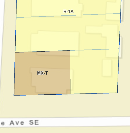
- A floating zone line will show as two different zones on one parcel.
- Example: In the image below, the platted parcel lines are shown in blue. The parcel at the bottom has both MX-T and R-1A zoning on it, and therefore it has a floating zone line.
Any property with a floating zone line is eligible for a voluntary zoning conversion to eliminate the floating zone line.
- The first step is to find out your property’s zoning. You can enter your address into the top search bar on the IDO Interactive Map. The label that you see is your zone (e.g., R-1B or MX-L).
- See FAQ: How do I look up my zoning?
- The second step is to identify the IDO terminology for your land use. The list of IDO land uses is found in the Allowable Use Table, Table 4-2-1, starting on page 149 of the IDO. The land uses are organized alphabetically, by category, starting with Residential Uses, Civic and Institutional Uses, Commercial Uses, Industrial Uses, and Accessory and Temporary Uses. If you have a question about what is included with each land use, the definitions under Section 7-1 may help.
- Once you know your zone district and land use, you can review the row with your land use on it to see if there is a P, C, or other letter in the column with your zone. If the cell is blank, that means the use is not allowed in that zone, and therefore it may be a nonconforming use.
- See FAQ: What uses can be developed on a property?
- See FAQ: How does the Use Table work?
- You may request a Zoning Certificate to confirm whether your land use is legal or legally nonconforming. The Planning Department may ask for additional information about when the use began to help determine if it was legally established prior to the IDO. Uses that were not legally established before the IDO are not considered nonconforming. If they are now allowed under the IDO, then they are now legal. If they are not allowed by the IDO, then they are still illegal.
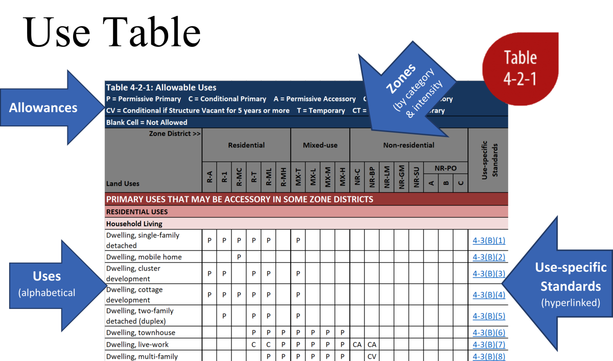
Once you know the zone district for your property, you can look at the Use Table from the Integrated Development Ordinance (IDO) to see the uses that are allowed in your zone.
Table 4-2-1: Allowable Uses makes it easy to see what uses are allowed in each zone.
Be sure to check the IDO to see if there are any Use-specific Standards that may expand or limit the use in certain zones or in proximity to other zones or uses.
For your convenience, here are two Step-By-Step Guides that will walk you through identifying allowable uses and key pieces of information for your property or the land use that you are interested in, as well as relevant parts of the IDO that can provide more detailed information.
If you know the zone district for your property (which you can find using the Interactive IDO Zoning Map), you can use the Allowable Use Table from the Integrated Development Ordinance to see the uses that are allowed in your zone.
To use the allowable use table, find the column for your zone and scan down the table to see what uses are allowed.
Zone districts (columns) are listed in three categories:
- Residential
- Mixed-use
- Non-residential
Within these categories, zone districts are generally listed from least intense to most intense.
Uses (rows) are organized into these categories:
Any sub-categories under those main categories are listed alphabetically. Uses under each category are also listed alphabetically.
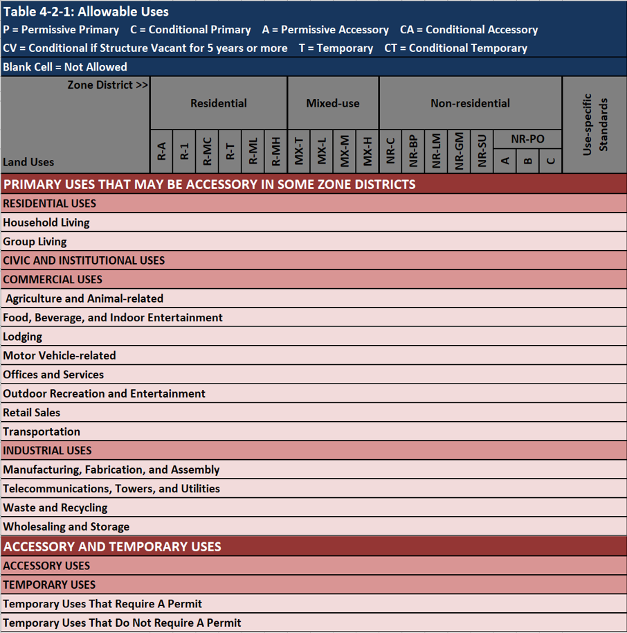
Uses may be allowed:
- Permissively as a primary use (P) or an accessory use (A), or
- Conditionally as a primary use (C) or as an accessory conditional use (CA).
Be sure to check the Use-specific Standards column and read the details in the referenced Subsection for additional allowances, restrictions, prohibitions, or standards associated with that use in your zone.
If you are familiar with Excel, you can also use the spreadsheet - turn on data filters, select the arrow next to the zone you want, and unselect "blanks". The table will then show you only the allowable uses in that zone. Clear filters to go back to the full table.
This file is provided for review and summary purposes only and reflects Table 4-2-1: Allowable Uses in the City of Albuquerque's Integrated Development Ordinance Effective Draft as of April 2025.
The Allowable Uses table in the Effective Draft of the IDO is the official version of this table.
To see only the allowable uses in a particular zone, turn on the data filter.
- Select the arrow in the column for the zone you are interested in.
- Un-check the "Blanks" row.
- To see all uses, clear the filter.
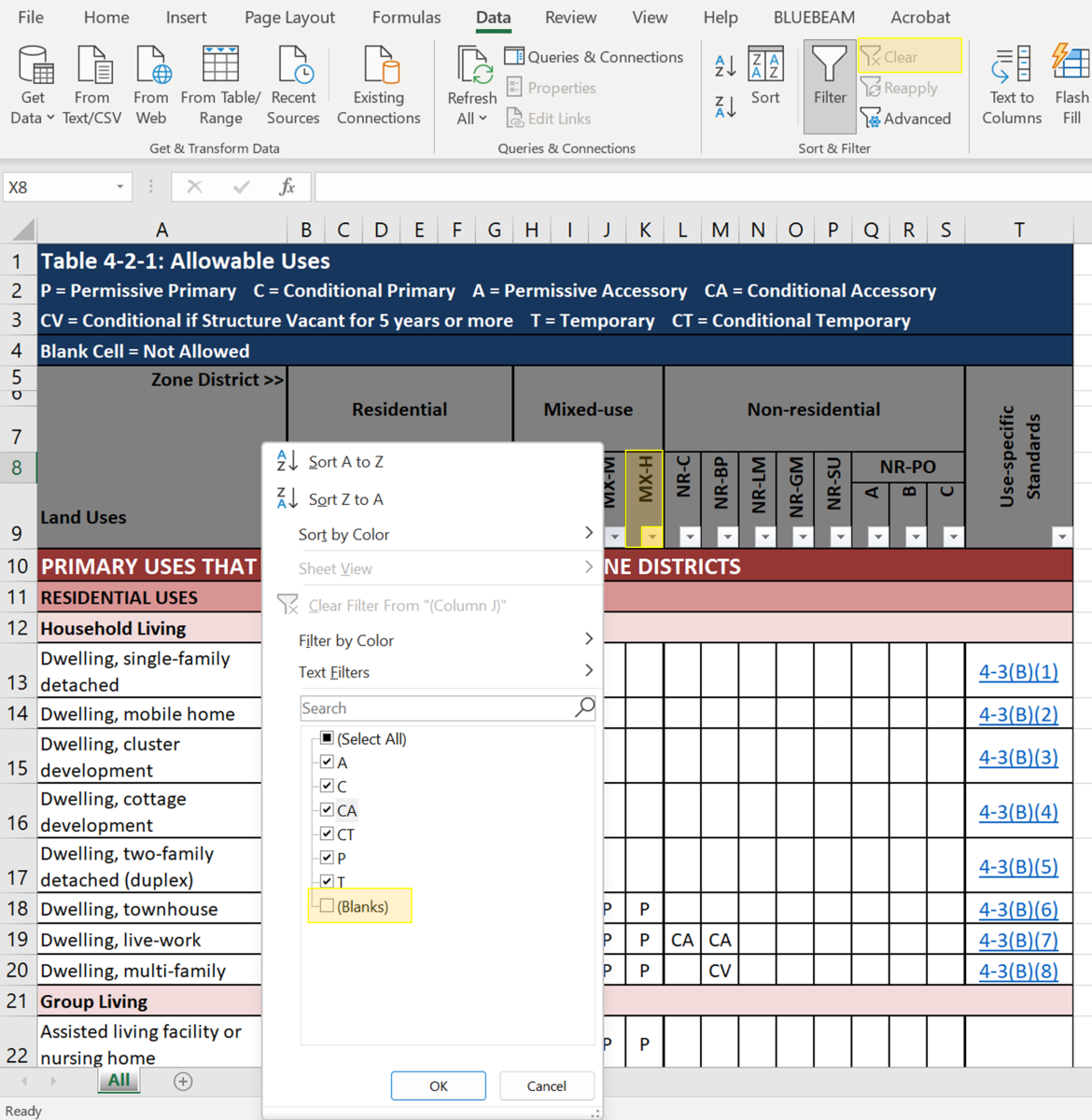
Table 4-2-1 Allowable Uses Downloadable File
See also:
A use-specific standard is a requirement or set of requirements for a particular use.
Use-specific standards may:
- Limit a use in certain zones, locations, or within a particular distance to similar uses or protected zones (such as Residential zones).
- Provide size limits for a use in certain zones.
- Provide additional design standards or buffering standards for a site to mitigate potential negative impacts of the use on surrounding properties.
- Provide information about local, state, and federal regulations, permits, or licenses that may be required for certain uses.
- Provide information about required distance separations between establishments with the same use or between Major Public Open Space and the use. Multiple uses have distance separation required from residential zones or uses. (See FAQ: What distance separations of uses and off-premises signs are required?)
Tip: Use-specific standards are found in the right-hand column of the Allowable Use Table 4-2-1. These section references are hyperlinked, so clicking that reference will take you directly to that use standard.
Examples:
In the Allowable Use Table 4-2-1, “Dwelling Unit, Accessory” is marked as “A” (Accessory) in many residential zone districts. The Use-specific Standard specifies that Accessory Dwelling Units (such as “casitas,” “mother-in-law quarters” or “carriage houses”) are permitted subject to a number of standards, including but not limited to a maximum square footage limit, a maximum height limit, building façade regulations, and setback regulations. (See FAQ: Can I have a casita or in-law unit on my property?)
“Liquor Retail” is allowed in certain zones but has further restrictions or allowances in some mapped areas or within a particular distance to Residential zones. (See FAQ: How is alcohol regulated in the IDO?)
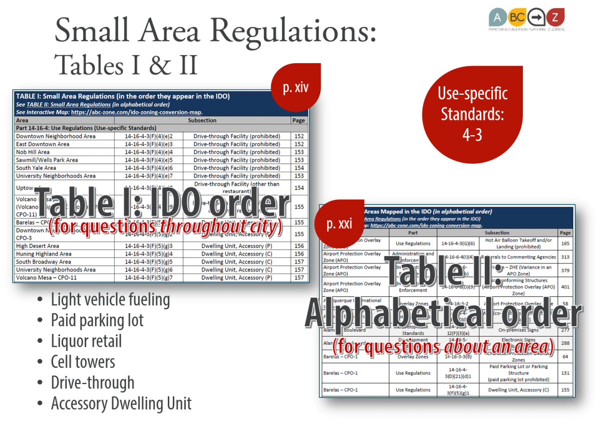
Index of Use-specific Standards Tailored for Small Areas:
- See Table I and Table II following the Table of Contents in the IDO for an index of all regulations in the IDO tailored for small areas/overlay zones.
- Table I is in the order of the IDO, so see Subsection 4-3 for use-specific standards.
- Table II is the same index organized alphabetically by small area/overlay zone. For each area, check for any use-specific standards in Subsection 4-3.
See also:
An Airport Protection Overlay (APO) zone is a collection of standards to ensure safety in and around the City's two airports: the International Sunport and Double Eagle II.
The APO zone is established in IDO Subsection 3-3 and includes limits on uses, development standards, and standards on transportation routes, hazard marking, and lighting that are different from citywide standards.
Tip: The APO is the only Overlay Zone that includes limits on uses. If uses differ in other kinds of Overlay Zones, the IDO establishes that in the Use-specific Standards in Subsection 4-3.
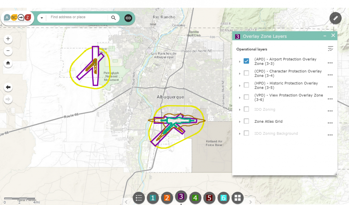
To see if your property is in an APO zone, use the IDO Interactive Map.
- Enter your property in the search bar at the top of the map.
- Click on button 3 at the bottom of the map.
- Check the box to the left of the "(APO) - Airport Protection Overlay Zone (3-3)" to turn on that layer of information.
- If nothing changes on the map around your property, you are likely not in an APO zone. You can zoom out until you see the boundaries of the two APO zones to confirm whether your property is in or out.
If your property is in an APO zone, review the standards in Subsection 3-3 of the IDO.
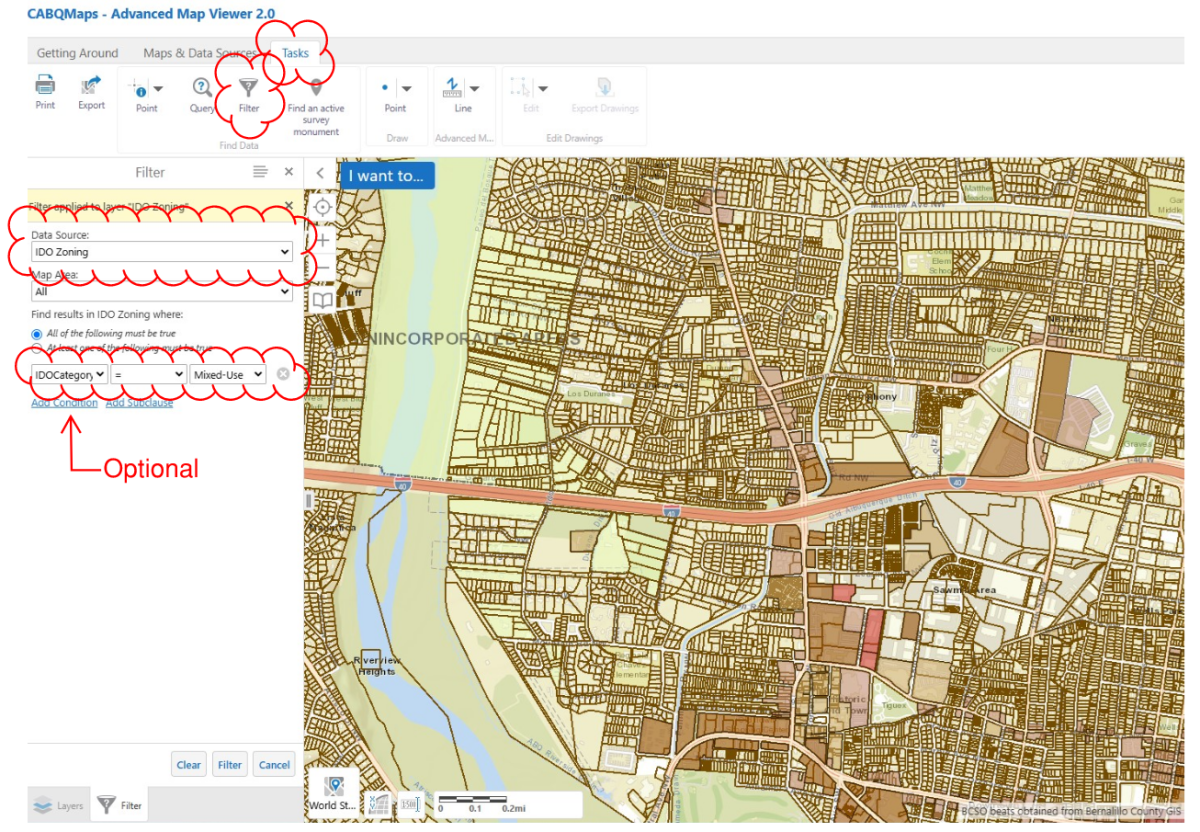
The best way is with the Advanced Map Viewer, using the "Filter" feature.
Instructions:
- Open the Advanced Map Viewer.
- Make sure the "IDO Zoning" layer is checked under Albuquerque Layers – Planning Layers – Comprehensive Plan – IDO Zoning.

- Under the Menu item “Tasks”, click “Filter”.
- Under Data Source, click “IDO Zoning”.
- In the box right above “Add Condition” choose “IDOZoneDistrict”.
- Keep the “=” sign in the middle box (or choose it, if it’s not there).
- In the box to the right of the = sign, choose the zone district you want to see.
- If you want to see more than one zone, click “Add condition” and repeat as many times as you want until all that you want are showing.
- Click “Filter” button toward the bottom of the side panel where you’ve been working.
- Zoom in or out to see them better.
The following uses are required to have a certain distance between them via a Use-specific Standard, which is cross referenced in Table 4-2-1: Allowable Uses and found immediately following the table. These section numbers refer to the Effective Draft from April 2025.
IDO Section | Use/Provision | Separation Distance
- 4-3(B)(10) | Group Home | 1,500 ft
- 4-3(C)(6) | Overnight Shelter | 1,500 ft
- 4-3(D)(6) | Adult Entertainment or Adult Retail | 1,000 ft
- 4-3(D)(23) | [Bank] Small loan businesses | 1 mile/5,280 ft
- 4-3(D)(26) | [Medical or dental clinic] Methadone centers | 330 ft
- 4-3(D)(26) | [Medical or dental clinic] Syringe exchange facility | 500 ft
- 4-3(D)(27) | [Personal and Business Services] Bail bonds | 1mile/5,280 ft (there is no separation requirement within 500 ft of a courthouse)
- 4-3(D)(35) | Cannabis Retail | 660 ft
- 4-3(D)(40) | Nicotine Retail | 1,000 ft
- 4-3(D)(41) | Pawn Shop | 1 mile/5,280 ft
- 4-3(E)(13)(e) | [WTF] Freestanding WTF | 1,000 ft
- 4-3(G)(9)(c) | Safe Outdoor Space | 660 ft when the use has more than 10 designated spaces and 15 or more occupants.
- Table 5-12-5 | Off-premises Signs in Mixed-use and Non-residential zone districts | 300 ft
Many other uses are required to be a certain distance from either an existing residential use or residential zone.
Yes, any property owner who rents all or part of their home (or an accessory dwelling unit on their property) for 29 days or less, must register with the City Planning Department. The IDO does not restrict short term-rentals in residential zones, as long as the building meets all other zoning standards that regulate building/site design or use. The following restrictions from the City Ordinance Code apply to short-term rentals (STRs):
- Each STR owner (person or corporation), must have a business registration with the City.
- Each separate rental unit (even if they are at the same location), requires its own STR registration.
- All owners must obtain required STR insurance.
- The maximum number of occupants is 2 people per bedroom, plus an additional general allowance of 2 additional occupants. (For example, a 3-bedroom house could have a maximum of 8 occupants.)
- Owners must report and pay all applicable taxes.
More Information:
- City of Albuquerque Business Registration
- Taxpayers Users Support: blt.str.support@govos.com or 888-751-1911
- File a complaint with the STR hotline 505-465-7710 or go to the online STR Complaint Form
Also, see Bed and Breakfast standards in IDO Section 4-3(D)(13)
- Bed and Breakfast businesses are distinct from short term rentals, and are defined as “A low-density residential development with no more than 8 guest rooms that are rented for temporary sleeping accommodations at market rates with breakfast served.” Bed and breakfasts are a regulated use in the IDO and must receive approval from the Planning Department.
- Where bed and breakfasts are allowed, they must be accessory to the primary use of the property as a single-family dwelling.
- Bed and breakfasts are a Conditional Accessory use in R-1 zone, which requires a separate process to obtain an approval for the Conditional Use.
Accessory Dwelling Units (also known as ADUs, Casitas and In-law Units) are allowed in all R-A and R-1 (single-family residential) zone districts in the City of Albuquerque. Additionally, they are an allowed accessory use in R-T, R-ML, MX-T, MX-L, MX-M, and in NR- (non-residential zones) as a caretaker’s unit. Remember to check the specific details of your zoning, as some Overlay zones have special standards for ADUs.
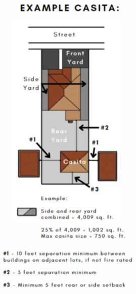
Some basic regulations for ADUs, can be found in IDO Section 4-3(F)(6):
- Only one ADU is allowed per lot and the maximum size is 750 square feet (Some other small area/overlay rules apply, so check your specific zoning.)
- A casita cannot take up more than 25% of the side and rear yards combined, nor can it be taller than the main house on the lot.
- An ADU may extend across the width of the rear yard, except for a passage of at least 5 ft, which must be provided at some point. Also, for fire safety, there must be a 10-ft separation between buildings on adjacent lots.
- The exterior color of the casita must be the same or similar to the color of the main house.
- One off-street parking space must be provided.
- If you already applied to have a casita on your property or have one that was built with the required permits before July 27, 2023, then you are considered to have a legally non-conforming accessory dwelling unit and do not need to do anything to “legalize” the dwelling. See more about non-conforming uses in IDO Section 6-8(C).
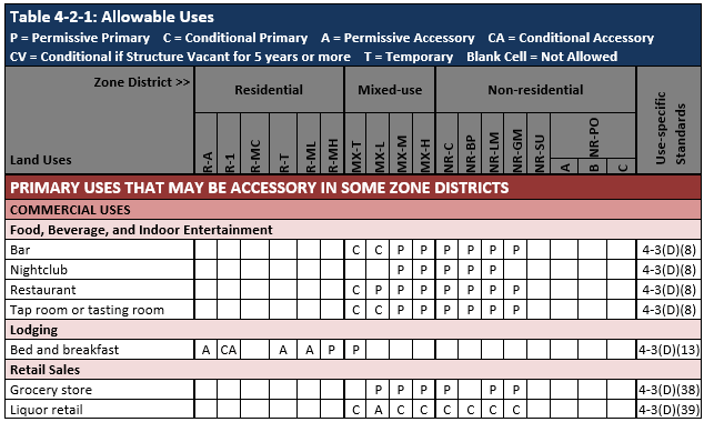
The sale of alcohol is regulated by the state through various permits for different types of alcohol sales. The City can regulate land uses that involve alcohol sales, but the intent is to generally complement state permits and to defer to the state's regulations.
More information on how alcohol sales are regulated under the IDO is provided below:
- Allowable Use Table 4-2-1 displays the zones where each use is allowed Permissively (P) or Conditionally (C).
- The IDO Zoning Map shows where these zones are mapped throughout the City.
- Information contained in the Use-specific Standard in the last column in the Use Table indicates if separation distances required.
- Specific definitions for each type of use that sells alcohol is located in Section 7-1.
There are several uses that allow alcohol consumption in the IDO. They are generally organized into the following categories in the Allowable Use Table 4-2-1:
- Food, Beverage, and Indoor Entertainment
- Bar
- Nightclub
- Restaurant
- Tap Room
- Retail Sales
- Liquor Retail
Distance Separations:
- State regulations for the 300-foot separation from schools and churches, remain effective but are not referenced in order to defer to applicable state regulations. The City may grant waivers to state's rules per City Ordinance 13-2-4.
- IDO regulations for the 500-foot separation from residential zones for off-premises consumption is in the Use Specific Standard for Liquor Retail.
Small Area Exceptions:
Regulations in several small areas only allow liquor retail in certain zones as accessory to a grocery store. (See "grocery store" definition in Section 7-1)
MX-L: Prohibited, except as accessory to grocery store in:
- Downtown Neighborhood Area – CPO-3
- East Downtown – CPO-4 and East Downtown – HPO-1
- La Cueva Area
- North 4th Street Corridor – CPO-9
- South Yale Area
MX-M, MX-H, and NR-C: Conditional use approval required, except where prohibited, or permitted as accessory to a grocery store:
- Downtown Neighborhood Area – CPO-3
- East Downtown – CPO-4 and East Downtown – HPO-1
- North 4th Street Corridor – CPO-9
- South Yale Area
- University Neighborhoods Area
- Prohibited:
- Nob Hill/Highland Area: This use is prohibited in all zones
See also:
The Federal Housing Act of 1988 established protections for “federally protected classes” to ensure that housing opportunities could not be denied to people on the basis of race, color, religion, national origin, sex, disability, or familial status.
The former Comprehensive Zoning Code in effect prior to 2018 used the term “Community Residential Programs” for group homes that provide services and programming and did not distinguish facilities that provide housing to “federally protected classes” from housing for non-federally protected classes.
The IDO defines “Community Residential Facility” as a residential use to provide housing for federally protected classes which includes:
- Physical or mental disability (including people in recovery from addiction)
- Family status
- Race
- Sexual orientation
In other words, the Fair Housing Act does not allow cities to have regulations on Community Residential Facilities that are stricter than any other residential use allowed in the same zone district.
The same types of facilities for non-federally protected classes are called “Group Homes”. The Use Table below specifies that Group Homes are not allowed in the R-1 zone district, whereas Community Residential Facilities are.
In both cases, these housing programs are subject to State laws for licensing.
Here’s where each use is allowed under the IDO per Allowable Use Table 4-2-1:
- Note that the last column includes Use-specific Standards (i.e. the fine print!) that further restricts these uses and provides additional requirements.
- The Use-Specific Standard for Group Homes requires that they be 1,500 feet apart and caps the total number in each Council district to a maximum of 30 group homes.
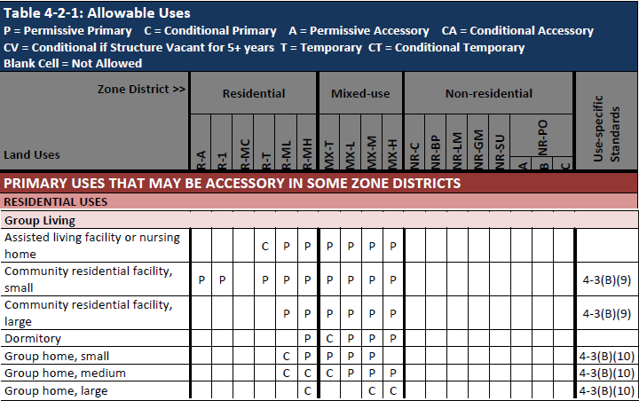
The size thresholds for small, medium, and large are included in the definitions for the uses in Part 7 of the IDO.
|
Size |
IDO – Group Homes |
Former Zoning Code* |
|
|
Small |
≤ 8 residents |
6-8 residents |
Up to 10 residents |
|
Medium |
9-18 residents |
N/A |
10-18 residents |
|
Large |
19+ residents |
9-18 residents |
19+ residents |
* The former Zoning Code specified different sizes for corrections programs, substance abuse programs, and others. See “Community Residential Program Handbook” available here:
The IDO defines these uses within the "Manufacturing, Fabrication, and Assembly" sub-category with the main "Industrial Uses" category. These uses include:
- Artisan manufacturing
- Cannabis cultivation
- Cannabis-derived products manufacturing
- Light manufacturing
- Heavy manufacturing
- Natural resource extraction
- Special manufacturing
The Allowable Use Table 4-2-1 shows which zones allow each use.
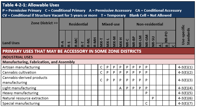
The Use Specific Standards in the far-right column establish additional rules for each use.
- Artisan manufacturing is limited to 10,000 square feet when located in any Mixed-use zone district.
- Heavy manufacturing and Special manufacturing cannot take place within 1,000 feet of a Residential use, within 660 feet of churches or schools, or within 330 feet of major public open space.
“Manufacturing Definitions” in Section 7-1 define each use, except that cannabis uses are defined under "Cannabis Definitions". (See "How does the IDO handle cannabis uses?")
In general, the IDO defines these uses as follows:
- Artisan manufacturing: Small-scale manufacturing by an artisan, artist, or craftsperson.
- Light manufacturing: Takes place in a building and does not ordinarily have impacts outside the building
- Heavy manufacturing: Can take place outside
- Special manufacturing: Involves processes or chemicals regulated by federal regulations
The City's Environmental Health Department and Air Quality Control Board is responsible for reviewing, approving, and issuing air quality permits that meet federal EPA standards.
The IDO regulates 4 cannabis-related uses as of the 2024 IDO Effective Draft.

- General retail - Applies to selling medical cannabis as regulated by the State of New Mexico (Sections 26-2B-1 to 26-2B-10 NMSA 1978 = the Lynn and Eric Compassionate Use Act).
- For zones that allow this use, see Table 4-2-1 Retail Sales in the Commercial Uses Category for General retail uses for small, medium, and large retail facilities.
- See Subsection 4-3(D)(37) for general retail use-specific standards.
- See Section 7-1 for definitions, including the size difference for small, medium, and large retail facilities.
- Cannabis retail – Applies to selling recreational cannabis as regulated by the State of New Mexico (Sections 26-2C-1 to 26-2C-42 NMSA 1978 = New Mexico Cannabis Regulation Act).
- For zones that allow this use, see Table 4-2-1 Retail Sales in the Commercial Uses Category for cannabis retail use.
- See Subsection 4-3(D)(35) for use-specific standards for cannabis retail. Some specific standards include:
- Prohibited within 660 feet of another cannabis retail establishment.
- Prohibited within 300 feet of any school or child day care facility.
- Conditional use required if on-site cannabis consumption is proposed.
- Odor control plan required if on-site smoking or vaporizing is proposed.
- See Section 7-1 for definition.
- See Cannabis Retail Location Approvals map.
- Cannabis cultivation - Applies to growing cannabis completely indoors.
- For zones that allow this use, see Table 4-2-1 Industrial Uses Category in the Manufacturing, Fabrication, and Assembly Sub-category for cannabis cultivation use.
- See Subsection 4-3(E)(2) for use-specific standards for cannabis cultivation.
- Conditional use required within 300 feet of school or child day care facility.
- Conditional use required if any outdoor activity is proposed in any non-residential zone.
- Odor control plan required for all cannabis cultivation facilities.
- Size limited to 10,000 square feet in any mixed use zone district.
- See Section 7-1 for definition.
- Cannabis-derived products manufacturing
- For zones that allow this use, see Table 4-2-1 Industrial Uses Category in the Manufacturing, Fabrication, and Assembly Sub-category for Cannabis-derived products manufacturing
- See Subsection 4-3(E)(3) for use-specific standards.
- Conditional use required within 300 feet of school or child day care facility.
- Conditional use required if any outdoor activity is proposed in any non-residential zone (aside from an approved screened incidental storage area).
- Odor control plan required.
- Size limited to 10,000 square feet in any mixed use zone district.
- See Section 7-1 for definition.
To see where properties are zoned for these cannabis uses, there are multiple maps that may be helpful.
- IDO Zone Districts Map - simplest map that allows you to see each zone district separately
- IDO Zoning Map - easy map that shows zoning and other IDO regulations for small areas
- Advanced Map Viewer - map with many tools and many different layers of information
- Cannabis Retail Location Approvals - map and dashboard that shows where cannabis retail locations have been approved
The City has a cannabis webpage that summarizes information about requirements and processes outside of zoning approvals.
Nicotine retail is defined by the State's definitions of nicotine and items related to nicotine-delivery. (See IDO Section 14-16-7-1).
Nicotine retail is a conditional use in most zone districts where it is allowed. A "C" in the allowable use table indicates that the use is allowed as a primary use on the property with a conditional use approval from the Zoning Hearing Examiner. Use-specific standards require that primary nicotine retail be located at least 1,000 feet from other primary nicotine retail uses and at least 500 feet from a residential zone district or lot containing a residential use in any mixed use zone district. (See IDO Subsection 14-16-4-3(D)(40)).
In MX-M, MX-H, and NR-C, nicotine retail is allowed accessory to general retail or a grocery store permissively, so a conditional use would not be required, and the nicotine retail use would not be required to meet the minimum distance separations above.
In NR-BP, NR-LM, and NR-GM, nicotine retail would always be considered a primary use, even if on the same lot as any other primary use, and would require a conditional use approval and required to meet the distance separations above.
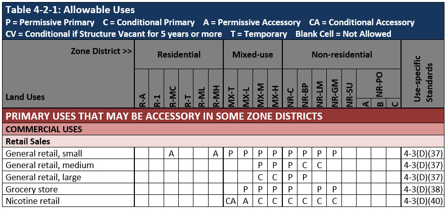
In the MX-T and MX-L zone districts, nicotine retail is only allowed as an accessory use associated with general retail or a grocery store. MX-T requires a conditional use approval; MX-L allows nicotine retail as an accessory use permissively. The use-specific standard limits the size the nicotine retail to 10,000 square feet of gross floor area.
What is cottage development?
A cottage development is a low-density residential community with small individual dwellings. Cottage developments typically include shared spaces, such as open space, gardening areas, community buildings, or parking. Although not required, if a cottage development includes a shared building, it could be used for activities, cooking, dining, etc. Any shared spaces are maintained through individual membership in a homeowners’ associations or a similar agreement.
In all zone districts, a dwelling unit cannot be larger than 1,200 square feet. In the R-A and R-1 zone districts, a dwelling unit must be at least 650 square feet.
Relevant IDO sections:
- 14-16-7-1 (Dwelling, Cottage Development)
- 14-16-4-3(B)(4) (Use-specific standard for Dwelling, Cottage Development)
Where are cottage development allowed?
Cottage development is allowed as a permissive use in the following zones: R-A, R-1, R-MC, R-T, R-ML, and MX-T. A cottage development is allowed on lots between 1 and 3 acres.
Relevant IDO sections:
- Table 4-2-1 (Dwelling, Cottage Development)
- 14-16-4-3(B)(4) (Use-specific standard for Dwelling, Cottage Development)
What density is allowed in cottage developments?
The density of a cottage development is calculated from the gross floor area allowed for dwelling units, instead of the number of dwelling units. Different zones allow a different number of units based on the minimum lot size of each zone and the square footage of the dwelling units that are built. This will typically result in more dwellings that are smaller in size.
The maximum square footage that is allowed is calculated by determining the number of dwellings that would be allowed if the property were subdivided based on the minimum lot size allowed by the zone, and then multiplying by 2,000 square feet, the size of a typical single-family dwelling (note: in the R-1D subzone, the assumed size of a typical single-family dwelling is 2,600 square feet). This maximum square footage can be divided into “cottages” up to 1,200 square feet in most zones or 650 square feet in the R-A and R-1 zones. Shared buildings do not count in these calculations. There are no regulations limiting the number of bedrooms in a cottage development, but the dwelling units must comply with minimum square footage requirements in the Uniform Housing Code.
Other regulations, such as parking, open space, and site acreage, further limit the number of dwelling units in a cottage development. Cottage developments are required to have one parking space per dwelling unit. In R-A and R-1 zone districts, two additional spaces are required per project for visitors to use. Also, in R-A and R-1 zone districts, 30% of a cottage development site must be usable open space, and balconies and rooftop desks do not count toward the requirement. In all zone districts where cottage development is allowed, the site must have a 10 feet landscape buffer on the sides and rear of the lot, and no buildings are allowed within the buffer.
Relevant IDO sections:
- 14-16-4-3(B)(4) (Use-specific standard for Dwelling, Cottage Development)
- Table 5-5-1 (Parking requirement for Dwelling, Cottage Development)
Examples:
The example below demonstrates one possible design for cottage development in an R-A zone, with shared parking and open space. The dwellings are 1,200 square feet, single-story homes. The project site has a total of 6 dwellings on 1 acre with 8 shared parking spaces.
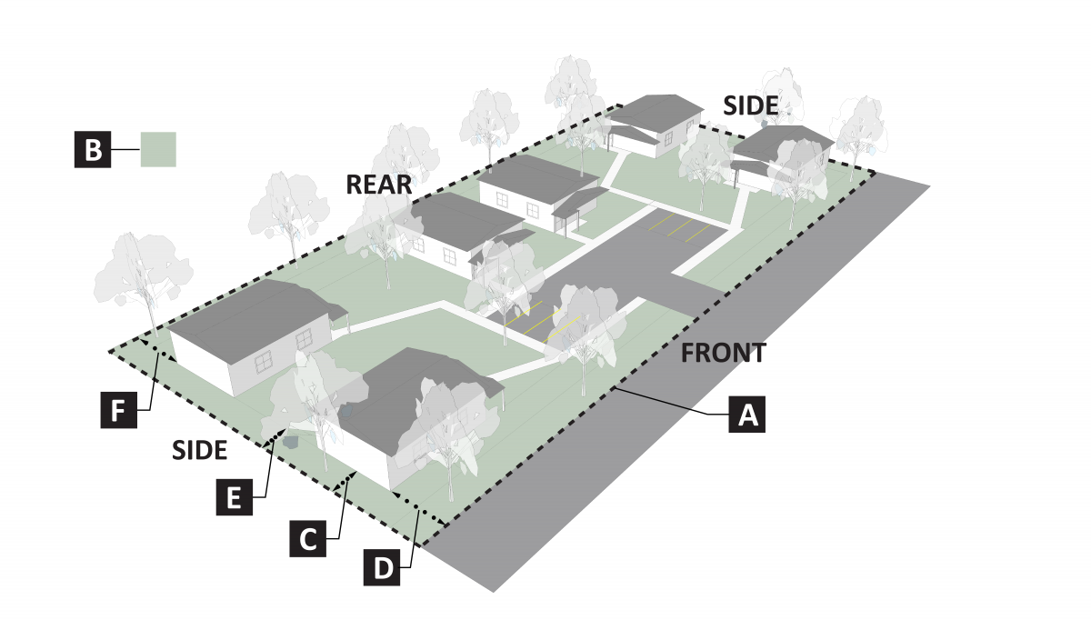
|
Cottage Development in R-A Zones |
||
|
Site Standards |
||
|
A |
Lot size, minimum |
43,560 square feet (1acre) |
|
B |
Usable open space, minimum |
30% of site |
|
C |
Landscape buffer on both side |
10' Landscape Buffer on Side and Rear of Site |
|
Setback Standards for the Cottage Development |
||
|
D |
Front, minimum |
20 ft. |
|
E |
Side, minimum |
10 ft. |
|
F |
Rear, minimum |
25 ft. |
The examples below demonstrate potential massing of dwelling units in varying zone districts. The project sites have a mixture of single- and two-story single-family units ranging from 650 square feet to 1,200 square feet. Because these designs do not reflect the site requirements mentioned above, such as parking, open space, or shared facilities, they show more dwelling units than could realistically fit on any particular site.
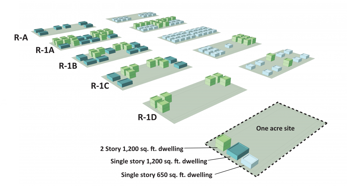
Similarly, the table below shows the maximum number of dwelling units allowed in each zone district, which would then be further limited by site requirements.
Assuming a 1-acre site, the following calculations show how to determine the total project density (allowed building size in Square Feet (SF)), the maximum number of units if they were the smallest allowed or largest allowed, and the amount of open space required.
|
Project Density Calculations – Number of Allowed Dwellings by Zone and Dwelling Size |
|||||||
|
Zone |
Calculation of # of Lots/Acre allowed in that Zone |
Allowed gross square footage |
Max units of 1,200 SF (smallest # of units) |
Max units of 650 SF (largest # of units) |
Required Open Space |
||
|
Lot min (SF) |
Lots / Acre |
# DU / Acre |
# DU x 2,000 SF |
Allowed gross SF / Unit Size SF |
30% x Site SF |
||
|
R-A |
10,890 |
4 |
4 |
8,000 SF |
6 |
12 |
13,068 SF |
|
R-1A |
3,500 |
12 |
12 |
24,000 SF |
20 |
36 |
13,068 SF |
|
R-1B |
5,000 |
8 |
8 |
16,000 SF |
13 |
24 |
13,068 SF |
|
R-1C |
7,000 |
6 |
6 |
12,000 SF |
10 |
18 |
13,068 SF |
|
R-1D |
10,000 |
4 |
4 |
8,000 SF |
6 |
12 |
13,068 SF |
What does a cottage development look like?
IDO regulations allow many configurations for cottage developments to provide flexibility for innovative designs. Most often, cottage developments would include small single-family homes spaced closer together than typical residential development to allow room for shared community spaces. In the R-T, R-ML, and MX-T zone districts, dwelling units in a cottage development can also be duplexes (two connected units) or townhouses (three or more connected units).
Dwellings can be centered around a shared design feature of the site, such as open space, parking, or a community building. A cottage development might cluster the dwellings and use open space to buffer a parking area. A landscape buffer is required around the site to provide a natural screen from surrounding uses, giving residents privacy and open space.
Relevant IDO sections:
What are the parking requirements for cottage development?
Cottage developments are required to have one parking space per dwelling unit. In R-A and R-1 zone districts, two additional spaces are required per project for visitors to use.
Relevant IDO sections:
Why did the City add cottage development as a new use in the IDO?
Cottage development furthers the goals of the Comprehensive Plan by promoting housing options, affordability, and sustainability.
- Adds to housing-type options: Cottage development is a form of the co-housing model, which allows for shared spaces and amenities while offering the privacy of an individual dwelling unit. Cottage development allows for multiple configurations to benefit various populations, such as older folks seeking to downsize but stay in their neighborhood or young families interested in sharing resources, like childcare.
- Creates opportunities for development of affordable housing: Cottage development can create more affordable housing options because of the potential for lower development costs associated with the smaller dwellings units, which can result in lower sale or rental expenses. Living costs can also be reduced if residents share expenses, such as by cooking in a shared kitchen or using shared laundry facilities.
- Promotes environmental sustainability: Cottage development can help prevent sprawl since it promotes in-fill development with area-appropriate density. It can also work to preserve open space and natural resources, especially in R-A and R-1 zone districts. Cottage development can also promote sustainable practices, such as shared gardening.
- Adds development that respects neighborhood character: Cottage development presents an opportunity to add density to a neighborhood without adding height and reflecting the character of surrounding single-family homes.
Are there any examples of cottage development in Albuquerque?
Acequia Jardin was developed before the Integrated Development Ordinance (IDO) was adopted. While it does not necessarily conform to all the IDO regulations for cottage development, it is a useful example of a cottage style development. Acequia Jardin is a “senior-focused community” on a one-acre lot on Rio Grande Boulevard next to La Montañita Co-op. There are 10 dwelling units on the site, all owner-occupied, and the units range between 800 and 900 square feet. The majority of the units share a wall, which mean they are considered duplexes by current IDO definitions and would not be allowed in new cottage developments in R-A and R-1 zones. Acequia Jardin also has shared living amenities, including a shared garden, guest casita, and community room, which are maintained through a monthly homeownership association fee.
Mixed-use zone districts are the only zone districts that allow both residential (multi-family) and non-residential (hotel) uses, so the hotel conversion would need to be located in a Mixed-use zone district.
Converting a hotel to multi-family dwelling would require a Site Plan – Administrative approval and building permit approval to issue a new certificate of occupancy under the new use. Both approvals are done via the submittal for building permit. Other requirements such as parking and usable open space per dwelling unit must be met.
IDO Requirements that May Be Implicated
- See Table 6-1-1 for requirements for notice for Site Plan – Administrative, including the requirement for email notice to Neighborhood Associations and sign posting on the property
- See IDO Subsection 6-5(G) for procedure for Site Plan – Administrative
- See Table 5-1-2 for the usable open space that must be provided on the lot for each dwelling unit in a Mixed-use zone district. Rooftop gardens, patios, and balconies would all count toward the usable open space requirement.
- See Open Space Definitions for the definition for Usable Open Space in Section 7-1.
- See Table 5-5-1 for the parking requirement for multi-family compared to hotel.
For More Questions
- Site Plan – Admin Development Facilitation Team
- Are you stuck in the process? The Planning Department now has two Navigators to help point you in the right direction? You can reach them at devhelp@cabq.gov
- City of Albuquerque Building Safety Division, 505-924-3320
- The City offers free Pre-application Reviews that allow applicants to ask questions and get answers from relevant staff
Campgrounds and RV parks are allowed in some Mixed-use and Non-residential zone districts as shown in Table 4-2-1: Allowable Uses.
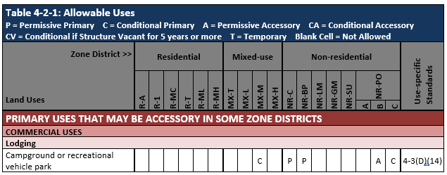
- A new campground will require a Site Plan – Administrative approval (assuming it includes <50,000 square feet of gross floor area of non-residential development).
- Code Enforcement will look for compliance with Use-specific Standards in Subsection 14-16-4-3(D)(14).
- Section 7-1 defines the use.
Food trucks are allowed as an accessory use as a mobile food truck on another property with a primary use (such as an office). If 6+ mobile food trucks will be on the property at a time, a Site Plan - Administrative is required, and the food trucks must meet use-specific standards in IDO Subsection 14-16-4-3(F)(12).
- Food trucks are allowed accessory uses in residential zone districts, limited to 12 days in any calendar year.
- While catering is allowed in residential uses as a home occupation per use-specific standard in IDO Subsection 14-16-4-3(F)(10), the definition of catering in Section 14-16-7-1 is limited to transportation and service off-site, and no retail sale on-site is allowed.
Food trucks are allowed as a primary use only if they are the only primary use on the property as a mobile food truck court. A Site Plan - Administrative is required, and the use-specific standards in IDO Subsection 14-16-4-3(D)(10).
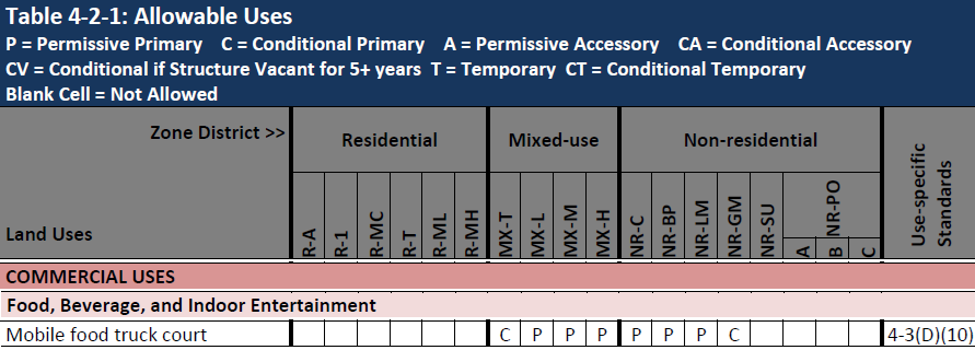
See:
- Table 4-2-1: Allowable Uses
- Use-specific Standards
- Development Standards
- Specific Procedures: Site Plan - Administrative
- Definitions
- Table 4-2-1 Allowable Uses
- Industrial Uses
- Telecommunications, Towers, and Utilities
- Solar Energy Generation: permissive use allowed in all zones with a use-specific standard in 4-3(E)(11) that says the use is allowed per state regulation
- Geothermal energy generation: accessory use allowed in all zones; it is a permissive primary use in NR-BP, NR-LM, and NR-GM
- Use-specific standard 4-3(E)(10)
- Wind energy generation or device: accessory use allowed in all mixed-use and non-residential zones; conditional primary use in NR-GM
- Use-specific standard 4-3(E)(12)
- Telecommunications, Towers, and Utilities
- Industrial Uses
- Section 7-1: Definitions
This table summarizes uses related to emergency housing for those experiencing homelessness or unsheltered people.
|
Proposed use/activity |
Regulation document(s) |
Summary of Relevant Limits / standards |
|
Overnight Shelter |
|
|
|
Safe Outdoor Space (Temporary) |
|
- All approved site plans stay in place, even if the IDO is adopted, so churches should not be affected by the IDO. (This is often referred to as “grandfathering in” existing, legal uses.)
- The approved site plan “runs with the land,” meaning the property can be sold, and the site plan remains in effect.
- The zoning “underneath” the approved site plan converted from SU-1 to an IDO zone.
- See the Zoning Conversion Map to compare pre-existing zoning and IDO zoning.
- Churches are allowed in almost all zones in the IDO, so this zoning conversion should have no effect on the use of the property as a church with related facilities.
- One benefit of the new zoning is that more uses of the property would be allowed, should the church decide to sell the property in the future. For this reason, church properties that are currently located within single-family residential neighborhoods with R-1 zoning have been proposed to convert to R-1 zoning, to ensure ongoing compatibility with residential uses in the future, even if the church use goes away.
- See Table 4-2-1 Allowable Uses – “Religious Institution” for the zones where religious institutions are allowed.
- See Section 7-1 Definitions for “Religious Institution."
-
If the church wants to make minor changes on the property, these can be approved administratively by staff. Larger changes (such as removing or adding a building, or subdividing the property.) would need to go back to the original decision-making body
Yes, the entitlements that come with your approved site plan run with the land, not with the owner. The new property owner can use the property as regulated by the approved site plan. If a potential buyer wants to use the site for something new, they will not need a new site plan if the new use is allowed by the approved Site Plan, and no major changes are needed for the existing buildings or site. A new site plan submittal may be required if the new proposed use is not allowed by the approved site plan, or if major changes are proposed for the site. Off-street parking requirements may be triggered for the new use.
- See Section 5-5 for parking standards.
- See Table 6-1-1 and Specific Procedure 6-5(G) for the projects eligible for Site Plan - Admin approvals.
- See also Section 6-4(W) Expiration of Approvals.
- See also FAQ: How does the IDO handle the review/approval process for development decisions?
See also:
The IDO establishes development standards for zone districts that apply citywide, but it also establishes development standards that are tailored for specific contexts that will prevail over citywide standards. To fully understand what development standards apply on a particular property, you will need to check citywide standards as well as contextual factors.
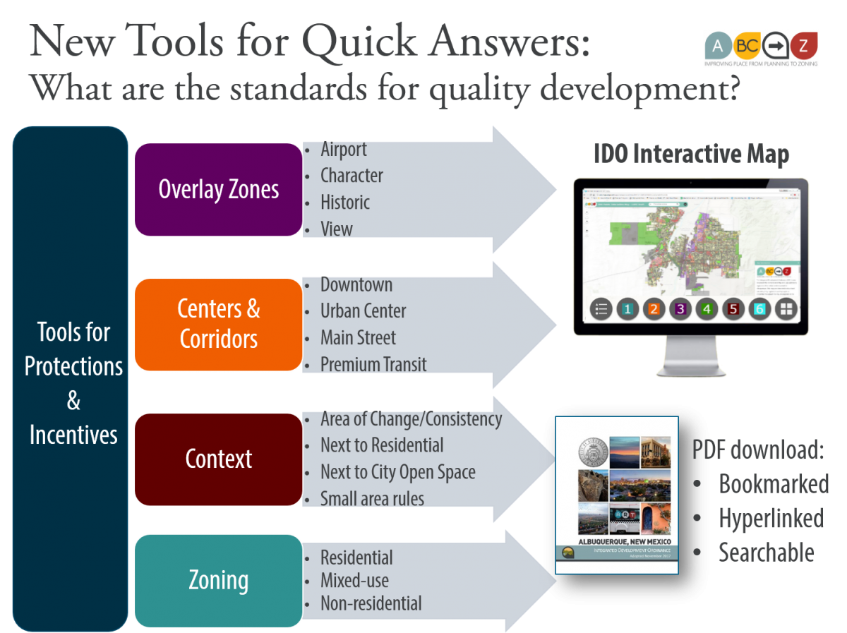
To find citywide standards that apply to your zone district, start with Part 2 – Zone Districts in the IDO, which provides summaries for each zone with key dimensional standards (building heights, setbacks, etc.).
Development standards are established and organized by topic in Part 5 – Development Standards of the IDO.
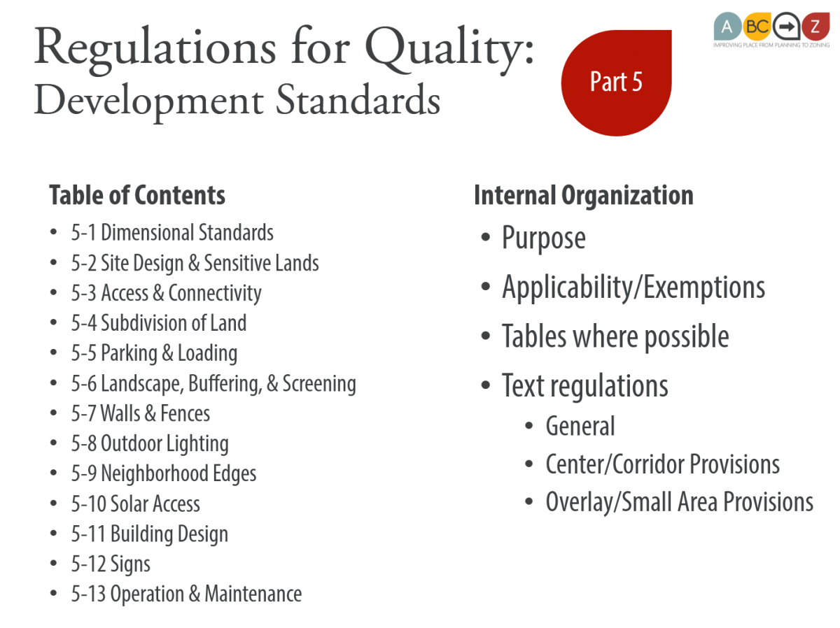
Note: The IDO establishes tailored regulations in the IDO for Center or Corridor areas to encourage more urban, walkable, and transit-supportive development.
- To check whether your property is in a Center or Corridor area, click on button 2 of the IDO Interactive Map and click the boxes to turn on the different layers of information.
- See Table III following the Table of Contents for an index of these Center and Corridor provisions.
Context Standards
The IDO establishes tailored regulations to protect residential uses, Major Public Open Space, and special places.
- Overlay Zones establish different development standards that prevail over citywide standards.
- To check whether your property is in an Overlay Zone, click on button 3 of the IDO Interactive Map and click the boxes to turn on the different layers of information.
- See the IDO Part 3 for development standards in each Overlay Zone.
- Development in Areas of Change adjacent to Areas of Consistency will be required to provide additional Edge Buffers to help protect development in Areas of Consistency.
- To check which City Development Area (Area of Change or Area of Consistency) your property is in, click on button 2 of the IDO Interactive Map. If either "IDO Zoning" or "IDO Zoning Background" are checked, click the boxes to turn those layers off. Click the boxes to the left of "City Development Areas (Change and Consistency)" to turn on that layer of information. Zoom in until the map turns yellow (Area of Consistency) or orange (Area of Change). You can enter your address into the search bar at the top of the map.
- See the IDO Section 5-6 for development standards associated with Areas of Change or Areas of Consistency.
- See the IDO Section 5-12 for different sign standards in Areas of Change and Areas of Consistency.
- Development next to Residential Uses or Residential Zone Districts may have different development standards to help minimize or avoid impact on residential areas.
- To check whether your property is surrounded by any Residential Zone Districts, click on button 1 of the IDO Interactive Map and turn on the "IDO Zoning" layer. Enter your address into the search bar at the top of the map to zoom to your property. Note the zoning of surrounding properties.
- To check whether your property is surrounded by any residential uses, click on button 1 of the IDO Interactive Map and turn on the "Land Use" layer.
- See these sections of the IDO for development standards that may be different.
- Development next to Major Public Open Space may have different development standards to help minimize or avoid impact on Major Public Open Space.
- To check whether your property is surrounded by any Major Public Open Space, click on button 1 of the IDO Interactive Map and turn on the "Major Public Open Space" layer. Enter your address into the search bar at the top of the map to zoom to your property. Note whether any surrounding properties are the green that signifies Major Public Open Space.
- Development in Small Areas mapped in the IDO may have different development standards to help tailor regulations to be compatible with and help protect small areas.
- To check whether your property is in a Small Area with different development standards, click on button 5 of the IDO Interactive Map and turn on the different layers of information. Enter your address into the search bar at the top of the map to zoom to your property.
- See Table I or Table II in the IDO following the Table of Contents to see indexes of all the small area provisions in the IDO.
See also:
Limits on WHERE You Can Park in Your Front Yard:
The IDO carries forward the existing prohibition of parking in front of homes anywhere except an improved surface, which was first added to the Zoning Code in 2007.
IDO Subsection 5-5(F)(1)(a)(6)
Parking in Residential zone districts or for low-density residential development is prohibited on any portion of the front yard setback other than on a driveway or drive aisle meeting the standards of this IDO and the DPM.
Parking of automobiles, trucks, trailers, boats, recreational vehicles, or other motor vehicles is prohibited on any required landscape or buffer area.
Limits on HOW MUCH of Your Front Yard Can Be Used for Parking:
The size of the improved surface for front yard parking is limited relative to the size of the lot:
For low-density residential development (i.e., single-family homes, duplexes, or townhouses) in all Residential zones (except R-A and R-MC), driveways and off-street parking areas are limited in size as follows:
Lot Size | Maximum Front Yard Parking Area
- ≥ 5,000 s.f. | 400 s.f. or ≤ 60%, whichever is greater
- < 5,000 s.f. and > 2,200 s.f. | 400 s.f. or ≤ 75%, whichever is greater
- ≤ 2,200 s.f. | 400 s.f. or ≤ 85%, whichever is greater
Limits on WHAT Parking Improvements Are Required:
Driveways and drive aisles are not required to be paved, but they must be improved for the purposes of parking and meet any technical standards in the DPM. The IDO makes this clear in Subsection 5-5(F)(3).
Limits on HOW to Get a Variance to Front Yard Parking Rules:
Subsection 6-6(O)(3)(c) adds a criterion for the Zoning Hearing Examiner to consider in whether a variance is appropriate:
- If there is one or fewer on-street parking spaces per dwelling within 330 linear feet of the property.
Limits on WHEN Front Yard Parking Requirements Apply (and can be enforced):
The IDO clarifies how front-yard parking rules will be enforced for development that happened before the effective date of the IDO in the Nonconformities Subsection 6-8(G)(2).
For development prior to 2007 (when City Council first adopted front yard parking regulations):
- If an improved parking area (e.g., driveway or drive aisle) was developed, that is the only area that can be used for parking in the front yard. The size is not limited to the size limits in the IDO and can be continued to be used for parking.
- If no improved parking area was developed, the amount of the front yard that can be used for parking is limited to the sizes in the IDO, but that parking area is not required to be improved.
For development between 2007 and the effective date of the IDO, improved parking areas that met the rules in place at the time they were built can continue to be used for parking. Parking is limited to those improved areas. If future updates to the IDO change the front-yard parking rules, existing improvements would be considered to be nonconforming and allowed to continue.
Limits on WHICH vehicles the Front Yard Parking Rules Apply to:
The IDO Section 7-1 defines "vehicle" by pointing to the City Traffic Code so that the front-yard parking requirements apply to boats and trailers, as well as automobiles.
See also:
Since 2007, the City has had rules about front yard parking, limiting parking to improved surfaces and limiting how much of the front yard those surfaces could cover.
The Integrated Development Ordinance carries forward those rules for all low-density residential development (single-family homes, duplexes, and townhouses) in Residential zone districts other than the Rural-Agricultural (R-A) zone. New development is required to follow these rules, which would require that the property owner build a driveway or drive aisle for off-street parking.
The Integrated Development Ordinance also clarifies what rules apply to development prior to the effective date of the IDO.
Development Prior to 2007:
- For improved parking areas built prior to 2007, the size limits do not apply, but parking is limited to the improved parking area.
- If the development does not have a driveway or drive aisle (because such an improvement was not required at the time of development), the size limits apply, but the parking area is not required to be improved.
Development between 2007 and the effective date of the IDO:
- Size limits that may change in the IDO in future updates will not apply, but parking is limited to the improved parking area that was constructed (which was required to meet the standards in place when it was built).
Here are some scenarios to illustrate how the front yard parking rules will be enforced going forward:
- A house built in 1929 has no driveway, the lot is 4,000 square feet, and cars are parked within the entire front yard setback.
- No driveway is required, but only 75% of the front yard setback area may be used for parking.
- A house built in 1965 has a driveway, the lot is 7,000 square feet, the drive area was enlarged with concrete in 1985 to cover 90% of the front yard, and cars are parked on this enlarged area,
- No action would be taken. This investment was made before the City adopted rules about front yard parking.
- A house built in 2003 has a driveway, the lot is 7,000 square feet, and cars are parked on the driveway and on landscaped areas:
- Cars can only be parked in the driveway. The driveway could be enlarged but is limited to 60% of the front setback area.
- A house built in 2004 has a driveway, the lot is 3,000 square feet, cars are parked on the driveway and on the landscaped areas, and there is no available on street parking because there are many curb cuts:
- Cars can only be parked in the driveway. The driveway could be enlarged but is limited to 75% of the front setback area. The property owner could request a variance for an area larger than 75%, since there is no on-street parking available within 330 linear feet.
Private covenants are not enforced by the City and are NOT reflected in the IDO.
The IDO discusses covenants in Subsection 1-9.
Any property with an approved Site Plan will be able to continue to follow that Site Plan and use the property as regulated by that Site Plan, regardless of the underlying zoning.
- Section 1-10(A) describes how approved Site Plans will remain valid after adoption of the IDO.
- See Section 6-4(Y) for the process for minor and major amendments.
If the property owner wants to make major changes to the site that require an amendment to the site plan, and elements of the site plan do not meet the new standards (i.e., they are “nonconforming”) the property owner may be required to come into compliance with some or all of the new development standards.
The IDO carries over solar protections in residential zones from the City's previous Zoning Code. The page numbers below refer to the effective draft as of April 2025.
- Table 5-1-4: Rooftop solar collectors are not subject to height restrictions.
- Section 5-4(E)(2)(b): Generalizes block layout for solar access in the Subdivision Regulations.
- Table 5-5-1: No parking requirement for solar or geothermal energy generation primary or accessory uses.
- Section 5-6(E): Edge Buffer Landscaping required where multi-family and non-residential uses are developed adjacent to residential zones. This larger setback will protect solar rights if larger buildings go in near residential land.
- Section 5-6(G)(1)(a): No screening of rooftop or ground-mounted solar energy equipment that would reduce the efficiency or effectiveness of the solar energy equipment is required.
- Section 5-9: Neighborhood Edges. Maximum building height is 30 feet within 100 feet of residential zones. Increasing the side and rear yard setbacks adjacent to residential zones a minimum of 10 feet beyond that otherwise required. This larger setback will protect solar rights for the adjacent lot.
- Section 5-10: Solar Access. Limits building heights on the northern lot line to ensure solar access (southern gain) of abutting properties to the north.
The IDO does not have any provisions explicitly allowing, disallowing, or regulating tiny houses. They are simply considered a house and can be built in all residential zones, as long as they follow other zoning and building regulations. There are some areas of note for those interested in tiny houses:
- If the tiny house unit is on wheels, it is treated as a recreational vehicle by the IDO, and must be located in a recreational vehicle park, following any rules associated with that park. Recreational vehicle parks can be located in the MX-M and NR-PO-C zone districts by conditional use and are permissive primary uses in the NR-C and NR-BP zone districts. A recreational vehicle may be stored on private property, but can only be used for dwelling proposes for a maximum of 14 days in any calendar year on any lot. (See IDO Subsection 5-5(B)(4)(d).)
- If the tiny house is not on wheels, it must be mounted on a foundation, connected to utilities, and follow any building codes or other zoning requirements. In general, this means that the unit must contain a minimum square footage of habitable area and meet any applicable setback standards. (See requirements from the Building Code here.)
The IDO includes new housing options in the Allowable Uses Table 4-2-1 for cottage development and revised standards for cluster development, either of which could allow tiny home villages, provided the tiny homes are on foundations and meet the building code. (See requirements from the Building Code here.)
- Dwelling, Cluster Development: A development design technique that concentrates single-family dwellings on a parcel, in smaller lots than would otherwise be permitted in that zone district, in return for the preservation of large areas of common undeveloped land, in a manner that would not otherwise be permitted in the underlying zoning district. Minimum project size for a cluster development is 1 acre. (See Use-specific Standard in IDO Subsection 4-3(B)(3).)
- Dwelling, Cottage Development: A shared interest residential community in which small individual homes are located on small un-subdivided parcels of land that are served by shared private roads, lanes, or infrastructure, and in which the development intensity is measured by the amount of gross floor area in residential dwelling units rather than the number of residential dwelling units. The maximum project size for cottage development is 3 acres. (See Use-specific Standard in Subsection 4-3(B)(4).)
- In the R-A and R-1 zones, there is a minimum dwelling unit square footage of 650 square feet and a usable open space requirement of 30% of the project lot. Balconies and rooftop gardens do not count toward that open space requirement.
The IDO incentivizes density in Centers & Corridors designated by the ABC Comp Plan as the most appropriate for urban, walkable development to help create vibrant places to live, work, play, and learn.
The IDO does not include a maximum dwelling unit per acre for each zone district. Instead, the IDO establishes performance measures that must be met, which will limit the number of dwelling units that a particular property can support. The following performance measures in the IDO impact density:
- Use-specific standards by use (IDO Section 14-16-4-3)
- Maximum building heights by zone district
- IDO Table 5-1-1 Residential Zone Districts
- IDO Table 5-1-2 Mixed-use Zone Districts
- IDO Table 5-1-3 Non-residential Zone Districts
- Minimum useable open space requirements for multi-family residential development by zone district (IDO Table 5-1-1 and Table 5-1-2)
- Minimum required off-street parking by use (IDO Table 5-5-1)
- Minimum landscape requirements (IDO Section 14-16-5-6)
- Neighborhood edge building height stepdown (IDO Section 14-16-5-9)
What is a Premium Transit Corridor?
How are transit stations identified for a Premium Transit Corridor?
Why does the IDO allow taller buildings and require less parking along Premium Transit Corridors?
There are 6 zone districts with unique review processes:
- MX-FB (Form-based)
- NR-BP (Business Park)
- NR-SU (Sensitive Use)
- NR-PO (Parks & Open Space)
- PD (Planned Development)
- PC (Planned Community)
For more information about review and approval processes for these zones, please see the following subsections in the IDO:
|
MX-FB |
District Standards |
|
|
NR-BP |
District Standards |
|
|
NR-SU |
District Standards |
|
|
NR-PO |
District Standards |
|
|
PD |
Eligibility for Rezoning |
|
|
PC |
Eligibility for Rezoning |
For all other zone districts, the IDO uses the size and complexity of a project as the threshold for the level of review needed to establish the decision process and the decision-maker.
The IDO identifies three different kinds of decisions:
- Administrative Decisions (decided by staff based on objective regulations)
- Decisions requiring a public meeting or hearing (decided by a decision-making body based on objective regulations)
- Policy Decisions (decided by a discretionary decision-making body based on policy, as well as objective regulations)
The IDO sets out these three types of review/approval processes in Table 6-1-1. More notice is required for decisions requiring public meetings/hearings than administrative decisions, so that public input can be taken for larger and more complex development decisions. Lots of notice is required for policy decisions, which take place through public hearings where public input is a key component of the decision-making process by discretionary decision-making bodies.
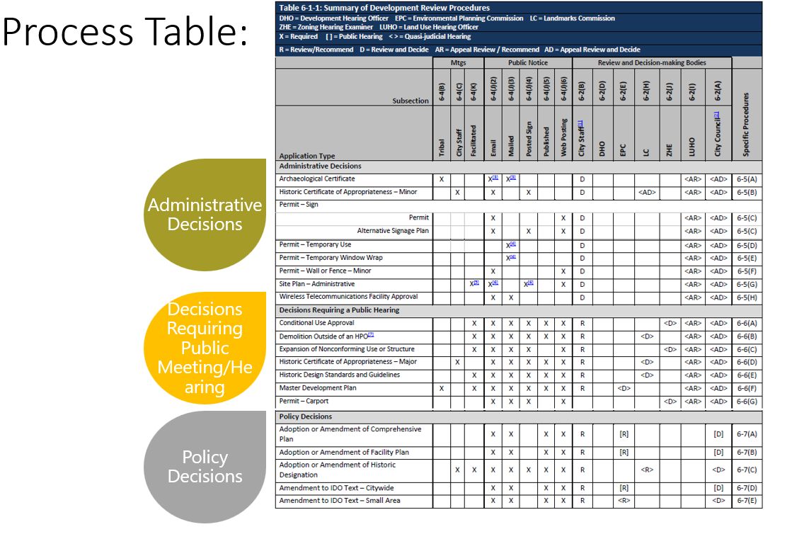
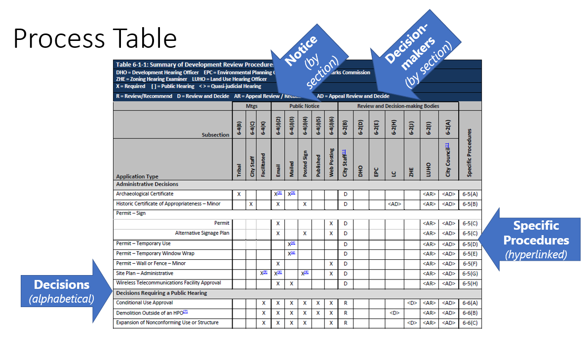
In order to justify a request or provide comments to decision-makers, it is important to respond to the review/decision criteria in the Specific Procedures for each type of decision.
- For Administrative Decisions and Decisions Requiring a Public Meeting or Hearing, decision-makers are deciding based on IDO requirements, DPM standards, and other City regulations that may apply.
- For Policy Decisions, decision-makers are deciding based on adopted City policies (such as policies in the ABC Comp Plan) in addition to IDO requirements, DPM standards, and other City regulations that may apply.
Forms for applications and descriptions of decision-making bodies, along with schedules with timelines for review/decision processes, are all available from the CABQ Planning webpage:
See also:
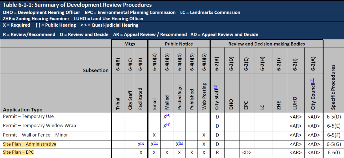
Table 6-1-1 in the IDO shows the process and requirements for 2 kinds of Site Plans:
- Site Plan – Administrative (reviewed and decided by staff)
- Site Plan - EPC (reviewed and decided by the Environmental Planning Commission)
Review the Specific Procedure for each decision to see which zones and which projects the decision applies to. For most zone districts, Site Plan - Administrative sets out size thresholds for projects under which staff can review and decide on the application.
For MX-FB, NR-SU, and PD zone districts and some NR-PO projects, a Site Plan - EPC is required.
Online Tool: Which Site Plan Do I Need?
The project team has created this online tool to help determine which Site Plan might be required.
- Please note that this is not official advice.
For guidance about IDO processes and requirements or application questions the Planning Department offers Pre-application Review as an opportunity for prospective applicants to get answers from City staff about development proposals.
-
Apply for a Pre-application Review through ABQ-PLAN or learn more about Pre-application Review here.
See also:
The IDO sets notice requirements based on the size and complexity of the development projects in Table 6-1-1 and Part 6.
- Small, straight-forward projects can be reviewed and decided by staff administratively with little notice. (See "Site Plan - Administrative" in Subsection 14-16-6-5(G) for thresholds)
- Large, complicated projects that require zone changes and site plans are reviewed and decided by the Environmental Planning Commission and by City Council. (See PD, PC, NR-SU zones in Part 14-16-2)
- Extra-large, complicated projects require review and recommendation by the Environmental Planning Commission and review and decision by Council. (See PD, PC, NR-SU zones in Part 14-16-2)
Once an application for a decision listed in Table 6-1-1 is accepted as complete by the City Planning Department, property owners within 330 feet and Neighborhood Associations within 660 feet in any direction of the subject property may request a post-submittal facilitated meeting in accordance with 6-4(K)(1)(a).
Under the IDO, requirements for the different types of public notice depend on the size and scope of the project and the approval that the applicant is trying to get. (See Table 6-1-1 in the IDO for the full list of decisions. A summary just for Site Plans is included below.)
- Property owners within 100 feet and Neighborhood Associations receive mailed notice.
- Neighborhood Associations receive electronic mail (i.e. email) notice.
- IDO Subsection 6-4(J) describes the requirements for the different kinds of public notice in Table 6-1-1.

The IDO requires the applicant to use forms for public notice with required information. Forms and more detail are available from the CABQ Planning webpage:
See also:
No. In fact, the IDO provides more notice to Recognized Neighborhood Associations than required under the previous Zoning Code. Half the applications the City received under the old Zoning Code went directly to the building permit stage with a zone check along the way. No notice was required under this previous Zoning Code. Under the IDO, notice to Recognized and Non-recognized Neighborhood Associations is required by email for all site plans.

The IDO sets a size limit on projects that can be reviewed by staff for administrative approval. Under the previous Zoning Code, there was no size limit except for shopping centers (5+ acres) and Large Retail Facilities (90,000+ square feet). Under the IDO, larger projects require review by the Development Review Board at a public meeting or hearing.
Zone change requests and development in the PD, PC, NR-BP, and NR-SU zones continue to require review and decision by the Environmental Planning Commission or City Council at a noticed public hearing.
The IDO requires applicants to meet with Neighborhood Associations before the City will accept their applications for projects required to be reviewed at a public meeting or hearing. This new requirement provides more opportunities for neighbors to meet with applicants earlier in the process, so that concerns and opportunities can be addressed before the application is submitted to the City.
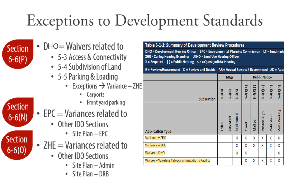
Variances and waivers are requests for a special exception to a regulation.
Under the IDO, these special exceptions can be requested from the following decision-making bodies and are considered at a public meeting or hearing, with opportunity for public comment:
- DHO = Waivers related to
- 5-3 Access & Connectivity
- 5-4 Subdivision of Land
- 5-5 Parking & Loading
- Exceptions:
- Front Yard Parking à Variance - ZHE
- Carports à Variance - ZHE
- Exceptions:
- EPC = Variances related to other IDO sections requested during consideration of a Site Plan – EPC
- ZHE = Variances related to other IDO sections requested during consideration of a Site Plan – Admin.
Table 6-1-1 shows the types of public notice that are required for each type of special exception. Note that a meeting with neighborhood associations is required prior to submittal of a variance or waiver request for all types of special exceptions.
Subsection 6-4(J) describes the notification distance for property owners and neighborhood associations.
Under the IDO, all appeals are heard first by the City Council's Land Use Hearing Officer (LUHO), who makes a recommendation on the appeal to Council, who accepts or rejects the LUHO's recommendation.
There are a few exceptions:
- Administrative decisions about a Minor Historic Certificate are first heard by the Landmarks Commission.
- Administrative decisions about Impact Fees are first heard by the Environmental Planning Commission.
- Decisions for City projects are considered final and are not subject to appeal to City Council (any appeals will be directly to District Court).
Only final decisions by each decision-maker can be appealed (i.e. continuances or deferrals cannot be appealed).
2. "Standing"
The IDO clarifies the parties who have "standing" to appeal decisions in Subsection 6-4(U)(2). Standing is granted based on proximity to the subject property for property owners and Neighborhood Associations in Table 6-4-2. Generally, for minor decisions, the distance is smaller; for major decisions, the distance is greater.
Under the IDO, the specified distance includes the right-of-way but includes the adjacent properties if the right-of-way is larger than the distance specified in the table that grants automatic standing. This measurement will be much easier for administrative staff to automate to generate notification lists.
3. "Harm"
The IDO grants standing to appeal to anyone who can show harm. The IDO language about the adverse effect of a decision closely aligns with case law in New Mexico clarifying what constitutes harm.
4. "Appearance of Record"
The IDO requires that for decisions that were made in a public meeting or hearing, the appellant must have made an appearance of record during the decision-making process, either by sending written comments or verbal testimony at the meeting or hearing.
5. Fees
The application fee for appeals can be found on the City’s Planning webpage.
The IDO uses the term "zoning map amendments" for zone changes. Under the IDO, Council decides all zone changes of 10+ acres in Areas of Consistency, areas mapped in the Comprehensive Plan where the existing character, scale of development, and patterns of the built environment are to be protected and reinforced. Council also decides all zone changes of 20+ acres in Areas of Change, areas mapped in the Comprehensive Plan where growth is to be encouraged, including Center & Corridor areas, business/industrial parks, transit centers, and metropolitan redevelopment areas. Under these thresholds, zone changes can be reviewed and decided by the Environmental Planning Commission.
See also:
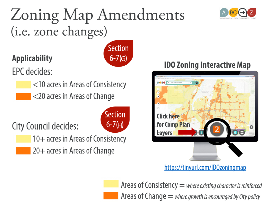
During a review/approval process, the applicant can ask for deviations from IDO standards within the thresholds in Table 6-4-1.
Beyond those thresholds, the applicant needs to request a Variance from the Environmental Planning Commission (EPC) or the Zoning Hearing Examiner (ZHE) or a Waiver from the Development Hearing Officer (DHO), depending on which standard the requested variance relates to.
Site Plans that were approved under the Zoning Code or IDO can be amended.
- Minor amendments can be granted administratively by staff within the thresholds of Table 6-4-4.
- Major amendments (changes beyond what's allowed as a minor amendment) can be granted only by the original decision-making body, using the same process.
|
Prior Approval (Before IDO) |
New Site Plan |
Amendment of IDO Site Plan |
|
|
Deviation |
As part of Major Amendment |
As part of Site Plan review |
As part of Major Amendment |
|
Waiver or Variance Waiver – DHO: Variance – EPC: Variance – ZHE: |
If more than deviation that is allowed as part of Major Amendment |
If more than deviation that is allowed as part of Site Plan review |
If more than deviation that is allowed as part of Major Amendment |
|
Minor Amendment |
|
N/A |
|
|
N/A |
|
Section and Table numbers refer to the Effective Draft of the IDO as of April 2025.
The U.S. Constitution's Fifth Amendment protects property rights from "takings" without due process from either regulations that deprive someone of all value in their property or from eminent domain that takes ownership of the property without "just compensation," which is typically payment of fair market value of the property.
Zoning establishes what uses are allowed on a property and the development standards that are required that might limit the use in order to protect the public health, safety, and welfare, which includes aesthetic benefits to the public.
An entitlement is granted at the end of the review/decision process for a particular use on a particular property, which is typically a building permit. The building permit must meet the requirements and conditions placed in all other prior approvals related to the same proposed development project.
The rules in place when an application is received during a phase of the development process are what govern that particular review/decision process for that application. Prior approvals from a previous phase remain valid and are considered during subsequent phases.
For example:
- A large piece of land is subdivided in 2018 per the rules in place at that time.
- In 2019, one of those subdivided parcels comes in for a site plan, and in the interim, the allowable lot sizes in that zone have changed in the IDO. The lot that was approved prior to those rule changes would still be allowed to be built on.
- In 2020, a building permit application is submitted for one of the proposed buildings shown on the site plan. Zoning staff would check that building permit against the site plan approved in 2019, even though some of the zoning rules may have been changed in the subsequent year. If the applicant wanted to take advantage of changes in the IDO made after 2019, they would need to either choose to amend their site plan approved in 2019 or submit a new site plan application in 2020 under the new rules.
- In 2021, another lot from the original subdivision comes in with an application for a site plan. Planning staff would review that application against zoning rules as of 2021 but would honor the lot sizes approved in the original subdivision.
In this example, the zoning sets the allowable uses and development standards. The entitlement of what's allowed to be built is granted at the end of the review/decision approval process when a building permit is pulled. Until that time, the government can still make regulatory changes to the zoning that may affect what can happen on the property, within the limits set by the Fifth Amendment. The government cannot require someone to actually build something, so if the applicant changes the proposed development, or ownership changes, or the market changes, an applicant can always submit an application that would change the proposed development project. As long as the application meets all the rules in place at the time it is submitted, a new approval can be granted.
There is a basic legal difference between zoning, which restricts uses, and a site plan, in which an applicant proposes a development project that they want to build. The site plan approval signals that the proposal meets the zoning rules in place at the time, but the approval does not require the property owner to build the project if they choose not to. A Site Plan is an allowance, not a requirement. It’s something the applicant wants and asks for, and which the City grants if the proposed site plan meets the rules in place at the time.
City Council, by adopting the IDO, changed the process by which someone can get a new site plan. The IDO allows Site Plan – Administrative review/decision for projects under the threshold that warrants DHO review/decision, and the IDO establishes the zone districts and uses that require a Site Plan – EPC. Those are all different from what they used to be.
The IDO offers 2 paths for property owners with a site plan approved prior to the IDO:
- Amending the pre‐IDO site plan because there is some use or development standard allowed in it that they want to hold on to. Amendments to pre-IDO site plans go back to the original decision-making body for major amendments, so it's also possible that the original review/decision process had an advantage for the applicant that warrants continuing to go back to that decision-making body to amend the site plan instead of replacing it under the IDO.
- Getting a new site plan because the IDO offers entitlements that they want and a process that they like.
The Integrated Development Ordinance (IDO) includes many protections for residential uses in Residential and Mixed-use Zones. The following sections refer to the IDO Effective Draft as of April 2025.
|
Subsection |
IDO Standard Referring to Residential ZONE DISTRICT or USE* |
|
Drive-through Facilities – Los Duranes CPO-6 |
|
|
Setback Standards, Other Development Standards - Sawmill/Wells Park CPO-12 |
|
|
Hospital |
|
|
Equestrian Facilities |
|
|
Kennel - MX-L & MX-M / NR-C, NR-LM, and NR-GM |
|
|
Adult Entertainment or Adult Retail |
|
|
Campground or Recreational Vehicle Park |
|
|
Car Wash |
|
|
Heavy Vehicle and Equipment Sales, Rental, Fueling, and Repair |
|
|
Light Vehicle Fueling Station |
|
|
Light Vehicle Repair |
|
|
Light Vehicle Sales and Rental |
|
|
Outdoor Vehicle Storage |
|
|
Construction Contractor Facility and Yard |
|
|
Medical or Dental Clinic (Syringe Exchange) |
|
|
Personal and Business Services, Small or Large |
|
|
Self-storage |
|
|
Building and Home Improvement Materials Store |
|
|
General Retail (Outdoor Display or Storage) |
|
|
Nicotine Retail |
|
|
Freight Terminal or Dispatch Center |
|
|
Helipad |
|
|
Railroad Yard |
|
|
Heavy Manufacturing |
|
|
Natural Resource Extraction |
|
|
Special Manufacturing |
|
|
Wireless Telecommunications Facility – Setbacks and Lighting and Signage |
|
|
Outdoor Animal Run |
|
|
Circus |
|
|
Cumulative Impacts |
|
|
Downtown, Urban Centers, Main Street Areas, and Premium Transit Areas (Off-site parking) |
|
|
Drive-through or Drive-up Facility Design |
|
|
Outdoor Storage Areas for Vehicles, Equipment, and Materials |
|
|
Walls & Fences - Materials and Texture - Barbed Wire |
|
|
Outdoor Lighting – General Design and Illumination |
|
|
Neighborhood Edges |
|
| 5-12(E)(5)(b) |
Signs – Illumination and Motion |
|
Alternative Signage Plan |
|
|
Referrals to Commenting Agencies |
|
|
Conditional Use - Review and Decision Criteria |
|
|
Waiver – Wireless Telecommunications Facility |
* This list includes provisions referring to a Residential zone district or "Residential use in any Mixed-use zone district."
The following sections of the Integrated Development Ordinance (IDO) have special use restrictions, subdivision standards, design and buffering standards for land near Major Public Open Space (i.e., open space designated in the Comprehensive Plan as Major Public Open Space) to ensure compatible development and protect these sensitive public lands from negative impacts of nearby development to keep these lands pristine in perpetuity (The following references are to the Effective Draft of the IDO as of April 2025).
There are no special setbacks required citywide for Major Public Open Space. Proposed development has to follow the Dimensional Standards Tables for required setbacks for each zone in Subsection 5-1. The exceptions to these setbacks by zone district are:
- Section 5-2(I) Major Arroyo Edges
- Section 5-2(G) Irrigation Facility (Acequia) Standards
- Section 3-4(C)(3)(a) Coors Blvd. CPO-2: 100-foot buffer strip from Corrales Riverside Drain
|
Purpose |
|
|
Sub-zone B: Major Public Open Space |
|
|
PD Zone District: Allowable Uses |
|
|
PD Zone District: Development and Form Standards |
|
|
PC Zone District: Allowable Uses |
|
|
PC Zone District: Mix of Uses and Housing Types |
|
|
Coors Blvd. CPO-2: Setback Standards |
|
|
(100-foot buffer required from Corrales Riverside Drain) |
|
|
Coors Blvd. VPO-1 |
|
|
Northwest Mesa Escarpment VPO-2 |
|
|
Listed Uses |
|
|
Use Specific Standards |
|
|
Dwelling, Cluster |
|
|
Dwelling, Multi-family |
|
|
Parks and Open Space |
|
|
Car Wash |
|
|
Car Wash |
|
|
Heavy Vehicle and Equipment Sales, Rental, Fueling, and Repair |
|
|
Light Vehicle Fueling Station |
|
|
Light Vehicle Repair |
|
|
Light Manufacturing |
|
|
Heavy Manufacturing |
|
|
Natural Resource Extraction |
|
|
Energy Storage System (ESS) |
|
|
Wireless Telecommunications Facility (WTF) |
|
|
Recycling Drop-off Bin Facility |
|
|
Solid Waste Convenience Center |
|
|
Waste and/or Recycling Transfer Station |
|
|
Warehousing |
|
|
Wholesaling and Distribution Center |
|
|
Drive-through or Drive-up Facility |
|
|
Drive-through or Drive-up Facility |
|
|
Safe Outdoor Space |
|
|
Contextual Residential Development in Areas of Consistency |
|
|
Major Arroyo Edges: Arroyos and Trails |
|
|
Major Public Open Space Edges |
|
|
Preventing and Mitigating Construction Impact |
|
|
On-site Pedestrian Connections |
|
|
Compliance With Zoning Requirements |
|
|
Planting in or over the Public Right-of-Way |
|
|
Additional Frontage Landscaping |
|
|
Abutting Arroyos or Major Public Open Space |
|
|
Roof-mounted mechanical Equipment |
|
|
Ground-mounted Mechanical Equipment |
|
|
Ground-mounted Mechanical Equipment |
|
|
Loading, Service, and Refuse Areas |
|
|
Loading, Service, and Refuse Areas |
|
|
Outdoor Storage Areas for Vehicles, Equipment, and Materials |
|
|
Satellite Dishes |
|
|
Walls and Fences: Purpose |
|
|
Walls and Fences: Applicability |
|
|
Maximum Wall Height: Walls Abutting Major Arroyos and Major Public Open Space |
|
|
Materials and Texture |
|
|
Materials and Texture |
|
|
Articulation and Alignment |
|
|
Wall Design |
|
|
Walls Adjacent to Major Arroyos or Major Public Open Space |
|
|
Illumination and Motion |
|
|
Prohibited Areas |
|
|
Parks and Open Space |
|
|
Responsibilities |
|
|
Rand 2 Facility Plans |
|
|
Pre-Submittal Tribal Meeting |
|
|
Applications for Variance - ZHE |
|
|
Development within 660ft of Major Public Open Space |
|
|
Site Plan - Administrative |
|
|
Site Plan - EPC |
|
|
Subdivision of Land - Minor |
|
|
Variance - ZHE |
|
See also:
Finding a Small Area Provision
Small Area Indexes
There are two tables of rules that apply in small areas immediately following the Table of Contents in the IDO. These tables index small area regulations carried over from Sector Development Plans adopted prior to the IDO. The tables indicate the type of regulation, IDO section, and page number.
- Table I is organized in order of the IDO. This table is useful in answering questions about all the areas throughout the City where there is a special provision that applies.
- Example: all the small areas that prohibit light vehicle fueling
- Example: all the small areas that allow accessory dwelling units in the R-1 zone district
- Table II is organized alphabetically by small area. This table is useful in answering questions about all the special provisions that apply to a particular small area in the city.
- Example: What are all the special rules for Barelas in the IDO?
- Example: What are all the special rules for Coors Boulevard in the IDO?
The IDO has six tools to tailor regulations to small areas.
- Character Protection Overlays (CPO)
- Historic Protection Overlays (HPO)
- View Protection Overlays (VPO)
- Use Specific Standards for small areas
- Development Standards for small areas
- Review procedures for small areas
IDO Zoning Interactive Map
To see small areas where special provisions apply, use the IDO Zoning Interactive Map, using the buttons that correspond to the IDO Section where the provision can be found.
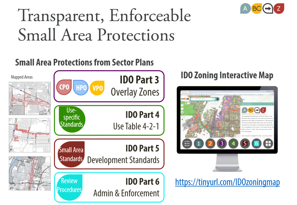
How the Small Area Provisions Were Decided
The ABC-Z Project Team went through the 60+ adopted Sector Development Plans to determine which plans included regulations. (Some only have policies and some have neither policies nor regulations but were created for annexation requests or to satisfy federal requirements for housing funds, for example.)
Staff then carefully analyzed the 40+ Sector Development Plans with zoning regulations.
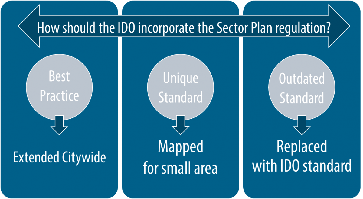
- Regulations and protections that are best practices (not unique to a particular area) were extended citywide, so that all areas can be protected. References to individual sector plans can be found in the footnotes throughout the searchable PDF document.
- Regulations and protections unique to a small area were carried over as mapped areas within which that regulation applies. There are over 200 provisions tailored for over 50 small areas maps carried over from Sector Development Plans in the IDO.
- Regulations and protections that were outdated, ineffective, or unenforceable were replaced by citywide standards proposed in the IDO, which are expected to provide better protections and higher design standards.
See also:
This presentation is a general overview of how the Downtown area is handled in the Integrated Development Ordinance.
This interactive map was created to illustrate zoning requirements in the IDO for small areas.
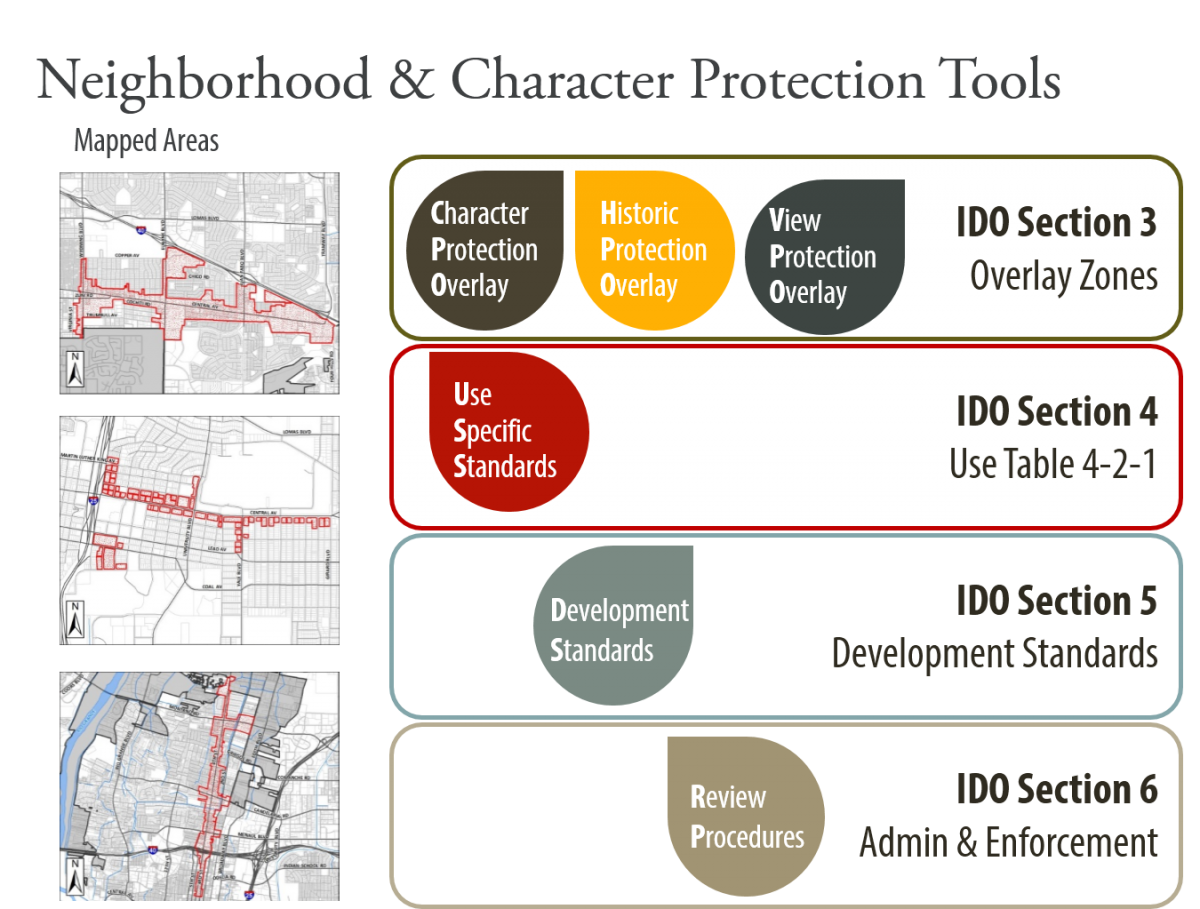
Use the round buttons on the bottom of the map to see different map layers:
- A legend
- Base layers (e.g. zone atlas grid, sector plan boundaries, parks, MRAs, Neighborhood Associations, etc.)
- Comprehensive Plan layers (e.g. Centers, Corridors, Change/Consistency Development Areas)
- Overlay Zone layers (e.g. APOs, CPOs, HPOs, VPOs, and MX-FB-DT)
- Use-specific standard layers (e.g. ADUs, drive-through prohibitions, paid parking lot prohibitions, and freestanding WTF prohibitions)
- Development Standards layers (e.g. mapped areas in Section 5)
- Administration & Enforcement layers (e.g. mapped areas in Section 6)
- Base map choices
Hover over the buttons to make the label for each appear.
See also the IDO for indexes of small area and Centers & Corridors provisions:
The Integrated Development Ordinance (IDO) helps to implement the ABC Comprehensive Plan's community vision to encourage walkable, urban development in Centers and along Corridors by establishing different development standards for these areas in Part 5 of the IDO.
To see if your property is in one of these Center or Corridor areas, use the IDO Interactive Map.
- Enter your property in the search bar at the top of the map.
- Click on button 2 at the bottom of the map and click on the boxes to the left of the layers of information you want to turn on. (It might help to uncheck the "IDO Zoning" and "IDO Zoning Background" layers to make it easier to see the Center and Corridor boundaries.)
- If nothing changes on the map around your property, you are likely not in a Center or Corridor area with special regulations in the IDO. You may need to zoom out on the map to see where those Center and Corridor areas are, if they are far from your property.
- If your property is in a Center or Corridor area, see Table III in the IDO for an index of all Center and Corridor provisions and review the relevant standards in Part 5.
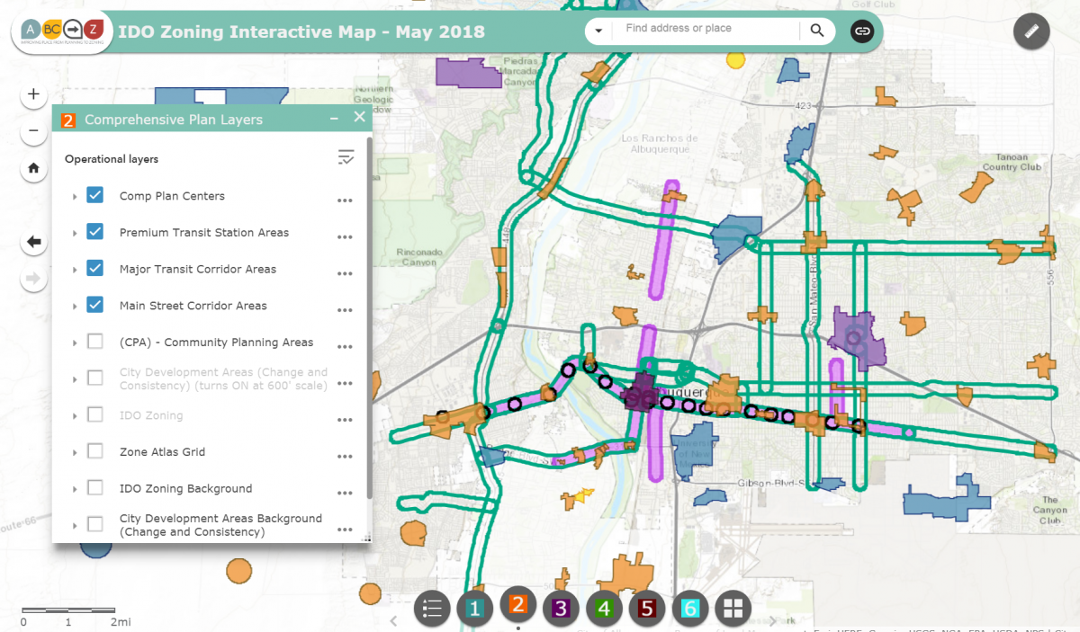
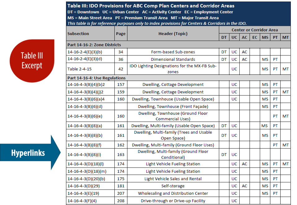
See also:
The City's Code Enforcement Division has a role in tracking state licenses for the following uses:
- Auto sales (ref. use, parking area, display area)
- CRFs
- Title services
- VIN inspection businesses
- Methadone clinics
- Liquor licenses (ref. land use for liquor hearings)
Zoning determines the allowable uses of the property, but zoning itself does not factor into the property value assessment that determines property taxes.
Property value is assessed by the Bernalillo County Assessor's Office. The assessed value of your property as of January 1 of each year determines your property taxes.
The Assessor looks at the existing uses of your property to determine whether your property will be assessed at one of two rates:
- a Residential rate if the predominant use of the property is residential.
- a Non-residential rate if the predominant use of the property is non-residential or the property is vacant.
The Assessor collects information about existing uses on properties through field data collection, canvases, building permits, and certificates of occupancy.
Changing zoning does not immediate trigger a valuation adjustment. What will trigger a valuation adjustment is any of the following:
- Changing the use of the property from residential to non-residential or vice versa.
- Making improvements on an existing building, or adding buildings to a property.
For owner-occupied homes, State law places a cap of 3% increase on valuation adjustments, even if the market value increases more [7-36-21.2 NMSA 1978]. This limit goes away if improvements or additions are made to the property or the property is sold.
To learn more about tax rates, contact the County Assessor's Office:
- Email assessor@bernco.gov
- Visit https://www.bernco.gov/assessor/
