O-24-69 FAQ's
What is O-24-69?
O-24-69 is a Council-sponsored amendment to the IDO that occurred outside of the Biennial Update.
O-24-69 went into effect on January 28th, 2025.
This bill was introduced at the January 6, 2025 City Council meeting by City Councilor Dan Lewis of District 5 and Joaquín Baca of District 2. The bill is titled:
“AMENDING THE INTEGRATED DEVELOPMENT ORDINANCE REGARDING APPLICABILITY, APPEALS, AMENDMENT PROCESSES AND EASING RESTRICTIONS ON HOUSING DEVELOPMENT.”
The bill passed 7 to 2 and was assigned Enactment Number O-2025-004.
See Also
- City Council website article: “Addressing Albuquerque’s Housing Through Smart Policy Reform”
- Find your City Councilor here.
- Contact you City Councilor here.
What is O-25-73?
O-25-73 is a Council-sponsored amendment to the IDO, which specifically amends changes made by O-24-69.
O-25-73 went into effect on April 21, 2025.
This bill was introduced at the February 19, 2025 City Council meeting by City Councilors Renée Grout of District 9 and Nichole Rogers of District 6. The bill is titled:
“AMENDING THE INTEGRATED DEVELOPMENT ORDINANCE REGARDING APPEAL COSTS.”
The bill passed 6 to 3 and was assigned Enactment Number O-2025-011.
See Also
How has the appeal process changed with O-24-69?
O-24-69 changed the requirements for who can file an appeal and changed standards related to appeal costs. O-25-73 revised appeal costs that were adopted by O-24-69.
Who can file an appeal:
To file an appeal based on proximity, Neighborhood Associations will need a petition of support signed by a majority of property owners/tenants of lots within 660 feet of the subject property. Property owner information within 660 feet of the subject property can be provided by the Bernalillo County Assessor.
Use of public land does not constitute standing for appeals (excluding Tribal standing for Indian Nations, Tribes, or Pueblos).
Neighborhood Association notification:
O-24-69 states that failure to notify a Neighborhood Association is not sufficient grounds to grant an appeal. This does not mean that applicants will no longer be required to notify Neighborhood Associations in accordance with Section 6-4(J) of the IDO. Planning staff requires proof of this notice as part of their review procedure, but in the instance that staff has erred, the lack of notice to the Neighborhood Association will not be sole grounds for an appeal.
Appeal costs:
O-25-73 removed the provision from O-24-69 below:
“The appellee may be responsible for paying the attorneys’ fees of the applicant if their appeal is denied. The proposed costs to be paid by the appellee will be determined by the Land Use Hearing Officer. When appealing a denial, all parties will be responsible for their own costs.”
O-25-73 added the following provisions:
- For an appeal to the LUHO related to an application that was denied, all parties shall be responsible for their own costs.
- For an appeal to the LUHO related to an application that was approved, if the appellant loses their appeal, they shall be responsible for paying a total of $1,000 for the costs and fees of the appellee. A finding on costs and fees shall be made by the LUHO. The $1,000 amount shall not apply to any individual appellant that demonstrates hardship, low income or indigent status, or entity appellant that has a majority of its area within an area that has an overall score of 50 or greater on the City of Albuquerque’s Social Vulnerability Index, as determined by the LUHO’s discretion.
See Also:
Can the IDO be updated outside of the Biennial Update process?
City Council is the City’s land use, planning, and zoning authority and can choose to amend the IDO at any time.
The IDO requires the Planning Department to submit proposed text changes every odd year. The Biennial process is described in Subsection 6-3(D) of the IDO, and amendments are reviewed against and decided through the criteria and process in Subsection 6-7(D) and 6-7(E). Council amendments do not require review and recommendation by the Environmental Planning Commission (EPC), and the IDO decision criteria for text amendments do not apply. Public notice for Councilor amendments to IDO text is the same as any other Council amendment.
See Also
- Albuquerque City Charter Article XVII - Planning
De behoefte aan meer spontaniteit in de slaapkamer heeft geleid tot een enorme populariteit van tadalafil, ook wel de weekendpil genoemd vanwege de lange werkingsduur. Het bestellen van Cialis zonder doktersrecept stelt u in staat om tot wel 36 uur lang klaar te zijn voor actie wanneer het moment daar is, wat een enorme mate van vrijheid en zelfvertrouwen geeft.
Is the City exempt from following the IDO?
The City is still required to follow the IDO, but O-24-69 clarifies the City’s role as it relates to City development projects and the role of Council in potential IDO updates.
City decisions:
Decisions applicable to City property and City development projects are considered final and are not subject to appeal to City Council. (Any appeals will be sent directly to District Court.)
IDO Updates:
O-24-69 specifies that amendments to the IDO can be made at any time by City Council. Amendments by Council are not required to be presented to the Environmental Planning Commission, but may be presented at the request of the sponsoring City Councilor. Albuquerque’s City Charter specifies that City Council is the City’s land use, planning, and zoning authority, which is reflected in this IDO amendment.
Can City Council adopt an Ordinance that conflicts with a goal or policy in the Rank 1 Comprehensive Plan? Don’t all regulations have to implement the Comp Plan?
The Rank 1 Comprehensive Plan is a policy document that sets out a community vision and goals and policies that the City should follow. Because of its broad scope and overlapping goals and policies, a new regulation does not have to implement them all, and some conflicts may occur. If City Council adopts an Ordinance that conflicts with a preponderance of goals/polices in the Comprehensive Plan, it could be in danger of being overturned or be subject to scrutiny if appealed to District Court.
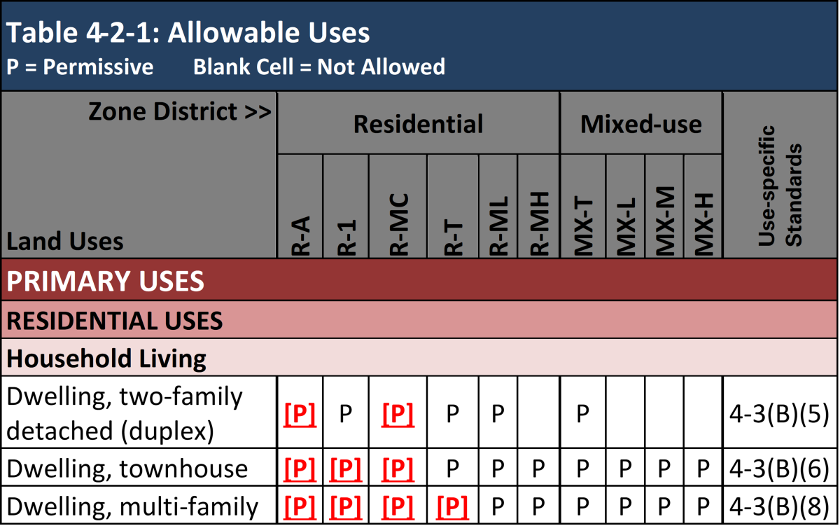
With this update, do I have more residential housing options on my property?
O-24-69 allowed more residential uses and unlimited building height for apartments within ¼ mile of Main Street (MS) and Premium Transit (PT) corridors.
Part 4 Uses and Use Specific Standards:
Changes to the Residential Household Living Category allow the following uses within ¼ mile of MS-PT areas:
- Dwelling, two-family detached (duplex)
- Dwelling, townhouse
- Dwelling, multifamily
- Does not apply South of Central Avenue and West of the Rio Grande
These uses are now permissive in specific residential zone districts within 1,320 (1/4 mile) of the MS-PT areas.
NOTE: Dwelling, multifamily use and use specific standards within 1,320 (1/4 mile) of MS-PT areas do NOT apply south of Central and west of the Rio Grande.
Is staff available to answer questions about O-24-69?
Please contact the project team at abctoz@cabq.gov with any questions or to request additional training on the IDO.
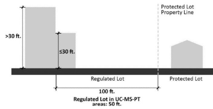
With this update, are there still building height limits on multi-family developments?
O-24-69 exempted multi-family dwellings from maximum building heights within 1,320 feet (1/4 mile) of MS-PT areas. Building height will still be limited by Neighborhood Edges [IDO Section 5-9(B)] and Solar Access [IDO Section 5-10]. The Neighborhood Edge requires that building height steps down to 30 feet within 50 feet of low-density residential development in MS-PT areas, and steps down to 30 feet within 100 feet of low-density residential development citywide.
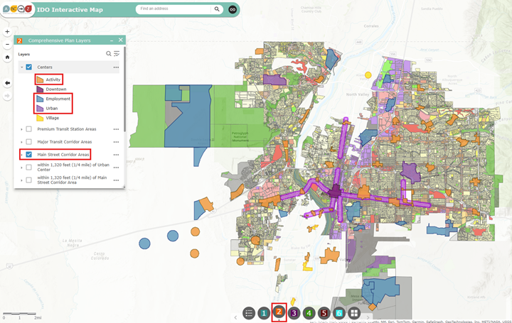
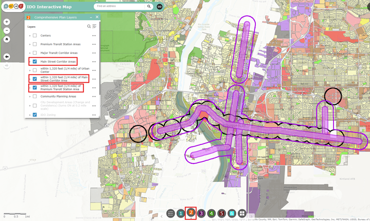
To determine whether a property is located within ¼ mile from MS-PT areas, visit the IDO Interactive Map and select Button 2 “Comprehensive Plan Layers”. Next check the boxes for Premium Transit Station Areas, Main Street Corridor Areas, within 1,320 feet (1/4 mile) of Main Street Corridor Area, and within 1,320 feet (1/4 mile) of Premium Transit Station Area.
With this update, could I put a multi-family dwelling on a lot that already has a single-family home?
Yes, as long as you met setback, usable open space, and parking requirements.
With this update, could an existing duplex add another dwelling unit?
Yes. It would then be considered a townhouse, which is also permissive within ¼ mile of MS-PT areas.
Is less parking required with this amendment?
Parking requirements may be reduced in certain Center and Corridor areas.
Centers and corridors:
O-24-69 increased the parking reduction in UC-AC-EC-MS areas from 20% to 50%.
To determine whether a property is located within UC-AC-EC-MS areas, visit the IDO Interactive Map and select Button 2 “Comprehensive Plan Layers”. Next check the boxes for Centers (which will display Urban Centers, Activity Centers, and Employment Centers) and Main Street Corridor Areas.
O-24-69 increased the parking reduction in MT areas from 20% to 50% in Areas of Change.
To determine whether a property is located within MT and an Area of Change, visit the IDO Interactive Map and select Button 2 “Comprehensive Plan Layers”. Next check the boxes for Major Transit Corridor Areas and City Development Areas.

Premium Transit areas:
O-24-69 increased the parking reduction in Premium Transit (PT) areas from 50% to 60%, for uses that do not have a PT reduction specified in IDO Table 5-5-1 and Table 5-5-2.
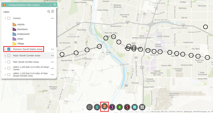
To determine whether a property is located within a PT area, visit the IDO Interactive Map and select Button 2 “Comprehensive Plan Layers”. Next check the box for Premium Transit Station Areas.
How do I know whether my property is within ¼ mile of MS-PT areas?
To determine whether a property is located within ¼ mile from MS-PT areas, visit the IDO Interactive Map and select Button 2 “Comprehensive Plan Layers”. Next check the boxes for Premium Transit Station Areas, Main Street Corridor Areas, within 1,320 feet (1/4 mile) of Main Street Corridor Area, and within 1,320 feet (1/4 mile) of Premium Transit Station Area.
Visit the Interactive IDO Zoning Map and select Button 2: Comprehensive Plan Layers. Check the boxes for within 1,320 feet (1/4 mile) of Main Street Corridor Area and within 1,320 feet (1/4 mile) of Premium Transit Station Area.
See also:
- IDO Table III: IDO Provisions for ABC Comp Plan Centers and Corridors Areas
- Albuquerque & Bernalillo County Comprehensive Plan, Chapter 3 The Vision, 3.3.2 Corridors
- IDO Section 7-1: Measurement Definition for Premium Transit (PT) Area and Main Street (MS) Area
- IDO Section 7-1: Center and Corridor Definition for Premium Transit (PT) Corridor and Main Street (MS) Corridor
- Premium Transit Corridors FAQs
- How does a Comprehensive Plan relate to a Zoning Code?
How do I know whether my property is in a UC-AC-ES-MS area?
Visit the Interactive IDO Zoning Map and select Button 2: Comprehensive Plan Layers. Check the boxes for Centers (which will display Urban Centers, Activity Centers, and Employment Centers) and Main Street Corridor Areas.

How do I know whether my property is in an MT area in an Area of Change?
Visit the Interactive IDO Zoning Map and select Button 2: Comprehensive Plan Layers. Check the boxes for Major Transit Corridor Areas and City Development Areas. Enter your address in the search bar to zoom in; otherwise, you will need to zoom in to see Areas of Change, shown in dark orange.
How do I know whether my property is in a PT area?
Visit the Interactive IDO Zoning Map and select Button 2: Comprehensive Plan Layers. Check the box for Premium Transit Station Areas.
Do the new regulations apply in Character Protection Overlay zones?
Character Protection Overlay (CPO) zones establish development standards in addition to those of the underlying zone district to protect distinctive community character, such as different building height or setbacks. CPOs do not regulate allowable uses.
O-24-69 may allow for duplexes, townhouses, and multi-family development within CPOs, but these uses will need to meet all CPO requirements as well as the use specific standards for the proposed use. If the CPO is more restrictive than the underlying zone district, the CPO requirements apply.
See Also
- IDO Table 3-2-1: Summary Table of Overlay Zones
- How do I look up my zoning?
- How do I find out what development standards apply to my property?
Will water rights be affected by O-24-69?
Please consult an attorney, the Middle Rio Grande Conservancy District, or the Albuquerque-Bernalillo County Water Utility Authority if you have questions about how new development might affect your water rights.